The Role of Property Surveyors in Resolving Boundary Disputes
13 July
If you own a home or land, it’s important to know where your property begins and ends to avoid land disputes between you and people with properties around you. When there’s a land dispute involving you and someone who owns property near you, it can be a stressful and unpleasant time. Regardless of who is involved in a boundary dispute, it’s important to resolve the issue as quickly as possible. While there are several entities that may get involved in resolving the dispute, none of them will be as important as the property surveyor.
If you are in a boundary dispute in El Paso, Land-Mark Survey can help determine where your land ends and begins. To learn more about our services, contact us online or call (915) 598-1300 today.
Steps For Conflict Resolution
Hire a Property Surveyor
Resolving a dispute around a boundary or property infraction is a tall order. Tensions are often high, and tempers are boiling, which makes mediation and resolution extremely difficult. That’s why it’s a good idea to get a property surveyor involved immediately. Property surveyors are unbiased professionals who’s only goal is to determine the exact location of your property boundaries, as well as those of your neighbor.
Discuss the Issue
Once you hire a property surveyor, it’s vital to discuss the property issue with them so that they have all the information. Land disputes happen for various reasons, and your property surveyor needs to know exactly what they’re looking for. Here are some of the most common reasons for a property dispute.
- Water or mineral rights
- A fence infraction
- Landscape or tree issues
- Rights to other natural resources
- Zoning restrictions
- Land use rights
Regardless of what the issue is, a land surveyor will help get it resolved as quickly as possible.
Gather All the Necessary Documents
As part of the resolution process, the individuals involved in the dispute will need to gather a wide range of legal documents, including the following.
- Deeds
- Land titles
- Sketch plans
- Property description documents
- Any previous land surveys
The Property Surveyors’ Role
Once the property surveyor has all the necessary documentation and paperwork, they will begin the surveying process. Land surveying is an exact science that can only get performed by qualified, certified, and licensed professionals. It’s a complicated process that will include the following steps.
- Plotting and locating property lines
- Measuring boundary lines
- Locating underground utilities and resources to determine whether or not you have the right to them
- Measuring and plotting any bodies of water on your land or running through it
- Plotting and measuring things in the air above your property, such as outstretched tree branches
Property surveyors will then document and report their findings to all the parties involved in the dispute and the authorities if necessary. To ensure they have taken accurate measurements and have properly determined the boundary lines, they will use the following tactics.
- Aerial photography and photogrammetry through the use of drones, planes, or choppers.
- GPS to ensure accurate latitude, longitude, and positioning.
- Land and geographic information systems
- Sub-surface engineering equipment when underground utilities, resources, and elements are involved.
If the conditions between the disputing parties are too hostile, property surveyors can also act as mediators in the negotiations. They will have all the evidence and proof necessary to bring the dispute to a speedy end.
Contact Land-Mark Survey to Resolve Boundary Disputes in El Paso
If you or someone you know is involved in a boundary dispute in El Paso, Land-Mark Survey is here to assist. We have the equipment and expertise necessary to resolve any boundary dispute, regardless of its scope or nature. Contact us online or call (915) 598-1300 today!
America’s Most Famous Land Surveyors: The Journey of Lewis and Clark (Part II)
29 January
Surveying and map-making began as a treacherous and rather dangerous enterprise. It wasn’t for the faint of heart. Lewis and Clark were one of history’s most important land surveyors. They and their crew would be responsible for changing the course and expansion of America. In our last post, we explored the background of Lewis and Clark and some of the surveying tools that they would take on their journey. Today we continue our remembrance of this historic expedition and the surveying marvels that were born from this trek across unknown lands.
Two Surveyors, a Guide, & Thousands of Miles
In addition to their early surveyor tools like compasses, quadrants, telescopes, and chronometers, Lewis and Clark also gathered other necessary equipment. Some of these included weapons and ammunition, medical supplies and medicines, books on botany, geography, and astronomy, maps, as well as gifts to present to Native Americans they knew they’d run into including beads, face paint, ivory combs, and more.
The duo recruited 45 brave souls to join them on their way westward. Among these were 27 unmarried men, a French-Indian interpreter, a boat crew, and Clark’s slave known as York. One other unique characteristic about the Corps was the fact that it was a rather eclectic and diverse bunch. In addition to the Southern roots of Lewis and Clark, there was his slave, a one-eyed-part-French-part-Omaha-Indian fiddler player, a German named John Potts, and the famous Sacagawea, a Shoshone Indian.
Both Lewis and Clark knew the journey would require incredible tenacity and discipline and so they ran a tight ship.’ Historical accounts describe how the corps was led with an iron fist, including harsh punishments like bareback lashing and hard labor for dissidents or uncooperative members of the team. It is the ultimate adventure story, only one person of the crew would die during the journey—a 22-year-old who died of an abdominal infection.
The team headed northwest along the Missouri River. Thomas Jefferson tasked them with several missions and goals for the expedition. These included finding and mapping a route across the continent, making detailed observations and notes regarding the natural geography, landscapes, and natural resources out West. At the same time, the team was meant to establish good relationships with native peoples along the way to interrupt the British dominance of the fur trade in the areas.
By mid-October, the expedition had reached the Mandan villages on the Missouri River. This important trading place allowed them to make some connections and talk to others about possible routes westward. The team had moved to South Dakota, North Dakota, and Montana. From the Mandan Villages, the crew was now facing the Rocky Mountains, the highest mountain range. One famous story was of Merriweather Lewis falling 20 feet into a cavern, was poisoned, and then shot in the thigh.
The now-famous Sacajawea, the wife of one of the Frenchmen in the expedition, proved to be invaluable for the success of the journey, as her language skills and knowledge of the territory proved essential. By the winter of 1805, they had reached the Columbia River and made a transcontinental crossing north of Mexico.
By the end, the expedition has traveled about 8,000 miles while pushing, pulling, and hauling ‘the boat’, the famous keelboat of the Corps, facing harsh storms, weather, hunger, thirst, and one or two run-ins with bears, friendly and not-so-friendly Indians, exhaustion, sleeplessness, mosquitoes, venereal disease, dysentery, boils, ticks, injuries, and God knows what else. The crew also found themselves face-to-face with some elk, buffalo, and deer, which they kindly turned into campfire dinners.
Throughout the trek, many of the men kept detailed journals, which would serve them well, as many of the maps and drawings they tried to send back to Jefferson during their journey never made it through. Finally, the crew made it to the West Coast, moving through northern Montana, Oregon, and present-day Washington onto Ft. Clatsop.
The Land Surveyors Return Home to a Hero’s Welcome
When Merriweather Lewis and William Clark returned to St. Louis with their crew, they were celebrated as pioneers and heroes of the time. The crew arrived back in St. Louis in September. The Corps of Discovery go their own way, but Lewis is named governor of the Louisiana Territory, while Clark becomes an Indian agent for the West. Most of the intended goals of the journey were met. This included establishing diplomatic relationships with Native Americans. The crew held councils with Indians and participated in events with them. Upon his return, Lewis had identified 178 plants including bitterroot, prairie sagebrush, Douglas fir, and ponderosa pine. They had also identified 122 animals such as grizzly bears, prairie dogs, and pronghorn antelope.
A Tradition of Land Surveying Continues With Unprecedented Precision
Lewis and Clark’s journey is seen differently among historians. For many, the journey was one of the first tales of American exceptionalism and would spearhead a movement of westward expansion and discovery. Others focus on the tragedies that plagued the journey. In the end, the expedition’s contributions to early maps of American territory are indisputable. The flourishing country understood its terrain and natural resources much more in-depth than it did before 1804.
As land surveyors, we can only admire the skill and technical understanding of Lewis and Clark in their creation of maps. Their understanding of geography, astronomy, and climate, allowed them to make extraordinary conclusions that turned out to be quite accurate.
While the process is much different today, here at Land-Mark Land Surveying, we move forward with creating detailed and accurate land surveys for construction, government contracts, and more. Connect with us to find out more!
Land Surveyors: The Enigmatic Nature of Mapping Out Our World
21 November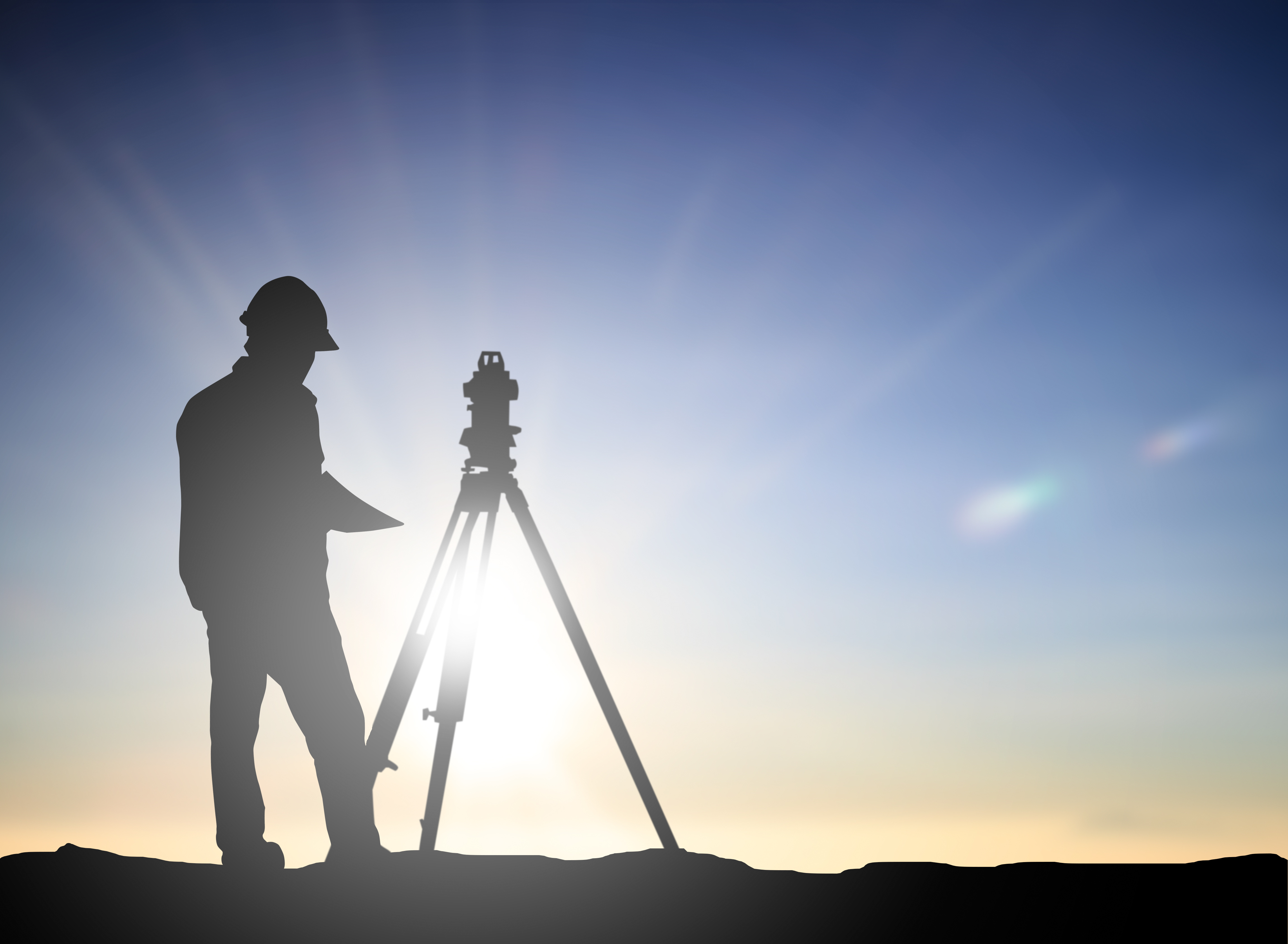 Land surveyors keep an ancient tradition alive. It’s true, land surveying extends far beyond the physical infrastructure. Everyone knows that the world is ‘connected’ today. When we use this phrase we usually refer to digital connections or avenues of communication across borders and oceans via social media sites or websites or access to the same or similar information. And while all that is true—that the world is figuratively more connected than ever—it is also true that there is physical work that is done in order to make these ‘connections’ possible. At the same time, the construction work we see on our way to work, the roadblocks that have us follow detours, all begin with an understanding of the land that is being built on, manipulated, changed. The work before the work is, in some ways, what makes land surveyors enigmatic and somewhat mysterious.
The Building Blocks—Geometry and Ancient Civilizations
Let’s take a step back in time. The concept of surveying or inspecting the land goes way back into civilizations. The division, understanding, and assessment of land serves many purposes and was used as far back as the ancient Egyptians for the purpose of taxation. Early surveys, used different types of instruments to gauge the dimensions of plots of land. According to Purdue University, in 120 B.C the Greeks developed geometry, although there were early versions of it in Egypt. Interestingly enough, the word Geometry means to ‘measure the earth’ and is the science of shape and size of things. Naturally, the science was then used to divide the land into shapes and plots, especially as civilizations grew, governments were established, and personal property needed to be measured and, yes, of course, taxed.
It was in Greece that the first piece of surveying equipment was developed. This was called the Diopter. This instrument was a mobile tool that used a cogwheel and water level to measure terrestrial and astronomical figures on a property. With this tool, the Greeks also developed a standardized method for surveying and basically created a protocol that set the stage for the process for many years.
And on to Europe and then the Industrial Revolution
You might remember a word or two about William the Conqueror from early history classes. Also affectionately known as William the Bastard, as his illegitimate birth was certainly a topic of conversation among royalty circles during his reign (his father impregnated a mistress), he ruled England from the time he was eight years old. Interestingly enough, William the Bastard’s reign was plagued with violence and turmoil, but he managed to maintain control and—despite not knowing English and being illiterate— made great contributions to the development of the English language in early England. He also made a great contribution to land surveying when he ordered a “Domesday Book,” a record of people who owned land in England and the sizes and shapes of their plots. This book placed a great emphasis on demarcating privately owned land and property.
The demarcation of personal property today—and if you are a property owner, then you are highly aware of this— is key in maintaining order and proper city records and plots. In 1571, the first theodolite was created. This was a more precise instrument, as compared with the diopter that came before it. The setup uses a tripod with a compass and is able to create boundary lines. It wasn’t until the 18th century, however, that plots of land began being measured with precise maps of where each was located.
In the 1800s, land surveying became an actual profession. And as the surveying tools improved, the process became more and more important. This was largely due to the rapid increase in population and the growth of cities, roads, and railways. Suddenly surveying land and understanding the landscape on which we built was much more of a necessity.
Land Surveyors in 21st Century Texas
You ask most people what the role of land surveyors is and they might come up with a relatively good educated guess. Most folks, however, know little about the process or understand that it is present before anything can get built. It’s why the surveyor is a kind of ghostly and enigmatic figure that comes in before the groundbreaking begins and plots out the land and territory.
Still in the 20th and 21st centuries, land surveying uses the same basic principles and concepts that were started centuries ago. The development of certain technologies, such as GPS, laser cameras, precision instruments, GIS software, and terrestrial scanning makes everything that much more accurate and efficient.
Surveying the Seas: Internet Cables that Run Our Online World
Another way that these surveying concepts are at work is through the network of cables that connect us all. As the internet has expanded, so has the infrastructure that supports it—even though it’s not often visible. It’s just another arena where the concepts and tools of land surveyors come into play. Fiber optic cable is laid out across the ocean floor to help connect people online. This is often referred to as the secret network that connects the world. It used to be that communications happened through copper cables and electrical signals. Today fiber optic cable that is laid across the land and ocean floor allows for the faster and secure communication we enjoy today. These fiber optic cables are often as thick as a human hair and carry pulses of late that transfer data.
Get An Accurate Land Survey with Land-Mark or Find Out More
At Land-Mark, we take the art of surveying very seriously. We have been in the business for many years and focus on providing accurate readings and maps of the land in question. Whether it is a government contract or a private enterprise looking for their next commercial location, accurate readings of property markings and coordinates are key in protecting yourself down the road from any legal troubles.
How Land Surveyors Shaped (and Continue to Shape) America
21 November Let’s transport ourselves to middle school history class. Do you recall the term “manifest destiny?” This was a 19th-century belief that the United States had a destiny (appointed by God) to expand across the entire North American continent. This was much more than a physical expansion of the nation; it was an expansion of the democracy and capitalism that was the foundation of the United States. Manifest destiny was much more than a belief, as it became a reality rather quickly. The Louisiana Purchase in 1803 doubled the size of the young United States, kicking manifest destiny into gear. Soon afterward, the famous Lewis and Clark expedition took place. Meriwether Lewis and William Clark were both land surveyors (amongst many other things) so they were the perfect candidates for such an expedition. This is just one example of the importance of land surveyors in America’s history.
How the Dominion of the United States Spread from East to West
The United States acquired large parts of Mexico in the early and mid 19th century. By 1846, we acquired the Oregon Territory thanks to a treaty with Great Britain. By 1850, the United States had grown to the size it is today. Fewer than 100 years after we declared independence from England, the United States ostensibly quadrupled in size. This is where land surveyors came into play. With so much land available, it was necessary for land surveyors to document each piece of the new America. Many land surveyors actually went on to become presidents of the United States. George Washington, Thomas Jefferson, and Abraham Lincoln all held the title of land surveyor. In fact, it was Thomas Jefferson who sent Lewis & Clark on their famous expedition of the Louisiana Purchase.
Land Surveyors Continue Making History
Although the days of early America are far behind us, land surveying still plays a major role in our modern society. Today, land surveyors pinpoint where your particular land begins and ends so you won’t accidentally build over someone else’s land. Surveyors are able to set boundaries as well. Many things have changed since the days of Lewis & Clark. Now, we’re able to use highly advanced technology to garner the most accurate readings. If you own land and want to begin developing it, make sure to speak with a land surveyor from Land-Mark Professional Surveying. We offer our services to clients in the Southwest regions of El Paso and New Mexico. When you partake in land surveying, you’re partaking in American history!
What Does a Land Surveyor in Odessa Do?
13 February We get asked all the time — What does a land surveyor in Odessa do? The truth is, the information that we provide within the construction industry is invaluable. We create maps and reports that help avoid catastrophic mistakes all the time. Building in one place or another on a plot of land can affect the timeline, building materials and equipment, and more. We provide information to help a project run smoothly and effectively.
What Does a Land Surveyor in Odessa Do?
A land surveyor is often hired to find the boundaries of a piece of property. This is valuable info for settling disputes, building roads, and creating maps. However, the job duties don’t stop there. They will also look into old surveys conducted of the property at hand. A surveyor will also take his own survey of the land utilizing special tools and expert knowledge. They will create a report and map of the area. The info is so accurate it is actually legally binding. The report that they create can help contractors find the most beneficial areas for building, drainage, parking lots, roads, and so on.
How Can a Land Surveyor Help Your Project?
A land survey of your building project is actually extremely necessary. You don’t want to start a project without a detailed account of your property and land conditions. The architecture will depend on the info provided. If you had previously decided to build in a certain portion of the property but then find out that water will flood the area when it rains you have to make adjustments. A land surveyor in Odessa can help you decide if altering the area would be sufficient to solve the problem. If problems arise that may have been unforeseen to you they can provide insight. This can include land that is extremely rocky and requires special equipment to dig into. Or perhaps soil that is too soft to build a foundation on.
Contact Us Today
If you are about to embark upon a new building project be sure to call our land surveyors in Odessa in to provide the info you need. We can help your building and timeline run more smoothly without the annoying hangups due to unforeseen circumstances. At Land-Mark Professional Surveying we provide thorough, reliable service. Contact us today before you get started on your next building project in Odessa.
A Land Surveyor Can Help With Pre-Construction Planning
16 January A land surveyor in Odessa can add value to any project. Utilizing the guidance and expertise of a surveyor is crucial to wise pre-construction planning. They have a wealth of experience in mitigating risks, determining site conditions, minimizing cost delays and so much more!
What Does a Construction Survey Consist of?
A land surveyor conducts specific services for a construction survey. This starts with an assessment of the current site conditions. They will find out how the current land will stand up to above ground and in-ground building infrastructure. They will also collect topographic data to map areas for drainage, piping, and manholes. Surveyors also stake elevations for footings. When you employ an experienced surveyor chances are they are probably already familiar with the land that its at hand. They more than likely are already familiar with the area’s soil, water, natural soundings, habitats, and even protected species. This kind of invaluable information can prove to be invaluable.
How Does a Land Surveyor Help With Pre-Construction Planning?
A surveyor will do much more that site analysis and boundary surveys. They can help to diminish the risks of future and possible regulation enforcement. You can be sure to be free of delays in project schedules when you have a land surveyor on your team. With regulatory planning you can also rest easy knowing your project startups will run more efficiently. Your surveyor will also have established standards for quality control, work production, safety, and schedules. This kind of guidance will only lead to improved project progress and heightened quality.
A good surveying firm will also have software and technology at their fingertips to assist you with planning as well. They will provide data to build models and 3D mapping. Geographic Information System, GIS, software and Building Information Modeling, BIM, are powerful tools to assist with pre-construction. The GIS is great for large scale planning. It is often used for resource management, infrastructure management, zoning and boundaries, market analyses and more. The BIM is useful in planning physical features. This can include gas, power line, communication lines, roads, and more.
Contact Us Today
Land-Mark Professional Surveying, Inc. offers a wide variety of services. Our land surveyors have expert knowledge to assist with pre-construction planning as well as a variety of other boundary and site analysis needs. Contact us today to set up an appointment.
Don’t Start A Project Without Consulting with a Land Surveyor First
23 October From the fabled days of the Wild West to today, El Paso has always been a city where paths converged. The same wild spirit of the days of yore resides within El Paso and within the souls of any entrepreneur with a dream of making the world a better place. In order to achieve this, you must team up with an experienced land surveyor from Land-Mark Professional Surveying.
The Land Surveyor and You
Simply put, land surveys give landowners the peace of mind that comes from knowing specifically where their property begins and ends. Instead of getting into land disputes with neighbors, you can choose a land surveyor to come out and survey your land. This will give you the ability to protect your land investment, giving you the ability to plan accordingly. Imagine how terrible it’d be if you hired an architectural firm and crew to design and build your dream shopping center only to find out, after all, construction has been completed, that your newly-constructed building encroached on three other property lines. This will cause stress and heartache. The best way to avoid this outcome is by starting off on the right foot: with a land surveyor!
Finding Success
Since land surveying is such a big deal, you need to make sure you’re hiring the right team for the job. By making sure your land surveyor is licensed and insured, you can rest easy in knowing that the land survey process will go off without a hitch. When it comes to land surveying, you need to choose the best of the best. The results will be used to build whatever you’re thinking of building. The survey will also be an important document to have as an entrepreneur. High-quality surveys aren’t a luxury, they’re necessary! If you’re looking to succeed in your future venture, don’t forget the land survey.
Hiring a Land Surveyor in El Paso
If you’re looking for the most experienced, reliable land surveying team in the El Paso area, choose Land-Mark Professional Surveying. Our team is ready to take care of your land surveying needs. Since we’ve been part of the community for over two decades, we understand what’s necessary for El Paso to thrive. Over the years, we’ve helped countless individuals, firms, and groups achieve their goals. Let our team help you get started on the right foot! Contact us today to learn more about what we have to offer.
The Immutable Necessity of Land Surveyors in Our Society
27 September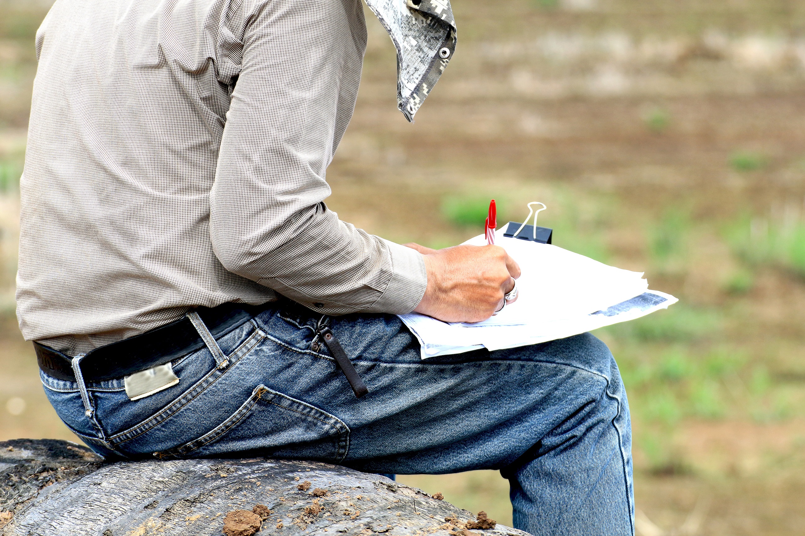 The city of Las Cruces, New Mexico is quickly growing. In order to accommodate for all the new, exciting opportunities that are making their home in the city, future entrepreneurs must team up with a land surveyor. This way, the land will be perfectly surveyed so any construction can take place correctly. Land surveys are the first “foundation” before any project can take place. Make sure you’re starting off on the right foot, choose Land-Mark Professional Surveying as your team today.
Why Land Surveying Matters
Land surveying has been an important part of human history for centuries. Nowadays, land surveyors makes use of highly advanced tools and practices in order to yield the most precise results. But why exactly is land surveying necessary, especially in this day and age where everything is accounted for? Well, that’s exactly the answer! Since everything is “accounted for,” a land surveyor can make sure the land which you consider your land is actually your land. Without land surveying, disputes can arise. Instead of dealing with this uncomfortable outcome, you can team up with a land surveyor!
How a Land Surveyor Offers Precision
Land surveyors make use of a plethora of studies in order achieve the most precise results. Geometry, trigonometry, physics and engineering are just a few of the elements that go into correctly surveying land. In addition to these sciences and mathematics, surveyors understand the proper laws. With this knowledge, your land can be surveyed accordingly and your project can move ahead without a hitch.
Land surveyors make use of equipment to yield the best results. Theodolites and global positioning systems are the land surveyor’s best friend. With these tools, the land will be surveyed for as precisely as possible.
Get Started on the Right Foot
Any entrepreneur who’s looking to build a new building over a plot of land they’ve just bought must first team up with a land surveying team. This way, the land will be properly accounted for and the boundaries will be set. Avoiding to do this can result in negative consequences. Say you build a large building in the plot of land you bought. If a few feet of your building bleed into the neighboring land (even if the land is barren and empty) you’re illegally on someone else’s land. This can end up in court, which is something you’d like to avoid. Land-Mark Professional Surveying is ready to help. Contact us today to learn more about what we have to offer!
What Does a Land Surveyor Do?
21 March While many people may have heard of the job of being a land surveyor, they might not necessarily know what one does. It is not a job that is typically talked about but it is an important job nevertheless. A land surveyor actually plays a huge role when it comes to building, construction, and overall city code and ordinances. There are legal processes that must be followed when building and construction take place, which is where this type of job comes into play. If you are in the Las Cruces area, Land-Mark Professional Surveying can assist you with any project you may be working on.
They Map Certain Areas
So you may still be wondering what a surveyor actually does when it comes to building and construction. Essentially, what they do is measure and map the areas in question. They use specific math and measuring devices to get accurate readings of the land around them. This is very important for projects so that they know what is around the land, what they should watch out for, and where their property ends and someone else’s begins. They do not do this alone however, they work with builders, architects, and engineers to get it all done accurately. It needs to be accurate for legal reasons as well as safety reasons.
They Determine Where Gas, Electric, And Water Lines Are
When it comes to safety, a land surveyor has a pretty important job. They are able to map out specific areas and make topographic maps, among other things. This means that they should be able to help point out where electric, gas, and water lines are for when the builders start construction. This is vital to know because the workers do not want to accidentally hit any of these lines. The electric and gas lines are incredibly dangerous and can be fatal if hit or cut. With a water line, you also do not want to hit it because it can become damaged and be very costly to fix. These are all important aspects of building and a surveyor essentially helps give a heads up to everyone when it comes to locations of certain things.
They Can Determine Property Boundary Lines
A land surveyor can also measure properties in case the boundaries are unknown. Sometimes people have disputes about whose property is whose. A surveyor can help determine where one property line ends and where another one begins. This can help dissolve any issues or disputes going on with different people. A surveyor does a lot for the government and city, and this is great in order to keep an accurate record of property lines, new construction, and much more. It may seem little but overall, it can be a huge help when people need to go back and look at or access specific information about their property.
Call Land-Mark Today
If you are in the Las Cruces area and need a quality land surveyor, our team at Land-Mark Professional Surveying can help you out today. Please contact us for more information or any questions you may have.
What is a Land Surveyor?
10 January There are probably many jobs most people haven’t heard of, like snake milkers and professional bridesmaids. A land surveyor, however, plays a significant role in building and construction. Before you build or renovate anything, it’s best to contact someone from Land-Mark Professional Surveying to help ensure you’re on the right track with your project.
What Does a Land Surveyor Do?
A land surveyor is also known as a cartographer. A person in this field measures and maps the environment using mathematics along with specialized technology and equipment. They can measure just about anything on land, in the sky or on the ocean bed. They can even measure polar ice-caps.
Land Surveyors work with engineers, architects and builders so as to produce precise descriptions of the surface of the planet. They also perform a variety of vital tasks including boundary surveys, topographic mapping, and construction staking.
You may need a surveyor to help measure your property in order to determine its boundaries. This information determines where roads or buildings should be constructed, settles property line disputes, and leads to the creation of maps. Moreover, any maps or land descriptions they supply are usually considered legally binding and can be presented in a courtroom setting. This profession requires people to be trained and licensed in order to work..
Other Facts
According to the U.S. Bureau of Labor Statistics, ” the duties of a land surveyor include making a record of the ‘distances, directions and angles between two points’ on the ground, using agreed-upon reference points, called benchmarks, as a starting point.” Surveyors also use global positioning technology to confirm a specific location. They carefully define the boundaries of interest, using both their on-site surveys and records found in land offices, in order to write the legal description of a parcel of land. Furthermore, land surveyors may use a geographic information system device to prepare a highly detailed, layered map of the results of a survey, in order to show all easements, soil conditions, and structures contained on a particular parcel. Surveys filed and recorded in public repositories, including county or parish clerk’s offices, are considered public records documents.
Both Michael Douglas and Hugh Grant starred in movies that had land surveyors as main characters. In addition, three out of the four presidents on Mount Rushmore, George Washington, Thomas Jefferson, and Abraham Lincoln, started as surveyors, as did Lewis and Clark. The Egyptian pyramids influenced land surveying. Land surveyors still use many of the tactics used back then today.
While not quite that old, Land-Mark Professional Surveying of Las Cruces has been in business since 1991. Put our 25 years of experience to work the next time you need property in the southwest region surveyed.