The Mapmakers of History: How Charting our World Became Essential for Civilization
24 March
Is a perfect map possible? For those of us who frequently use our smartphones to find our way around with no wrong turns, the answer might seem like a resounding yes. And yet, map makers and experts contend that there is no such thing as a perfect map. One expert claims that all maps are—to some degree—subjective and that all civilizations in the past have heralded their maps as the correct one when really each one depicts a subjective view. And yet, companies like Google have set on a quest to develop “the perfect map,” using every available tool to approach this much-romanticized perfection. Through satellite imaging, drone images, hikers, and more, Google is attempting to create the perfect picture of our world.
Over the centuries, human beings have engaged with the environment in an effort to better understand it and advance their societies. So here is the story of a few maps that changed the world.
The Early Days of Maps and How It Altered Human History
You may have heard someone say, “so-and-so has a good sense of direction.” Perhaps we recognize that some people are more apt in finding their way around than others. What is this about? Since the 1940s, some scientists have argued that humans have a kind of internal map or “black box” in the nervous system. While this may be true to some extent—we know how to get around our neighborhoods or familiar towns—drop someone in unknown territory and things can go south very quickly.
Yet, humans used this intuition to begin interacting with the world and trying to document it. One of the oldest surviving maps was a clay tablet created around 700 to 500 B.C. in Mesopotamia. This early map was small and primordial, as it was more about giving people a sense of the surrounding worlds by placing Mesopotamia at the center.
Early maps, in fact, were not overly concerned with accuracy. These early representations were more of a form of artistic expression or representing one’s fiefdom or kingdom. Some experts point to the early Roman maps, which seem to be more of a statement or showcase of their great empire than a document meant for navigation or understanding the land.
The First Attempt at Accurate Mapping
The first step towards accurate map-making was due to one man seeking to craft accurate horoscopes. One of the most often cited early maps was from Claudius Ptolemy, an astrologer and astronomer, who was preoccupied with horoscopes and somewhat inadvertently invented geography.
Ptolemy did the leg work to collect documentation that detailed locations of towns and used stories from travelers to embellish his maps. He slowly developed what became a system of lines—latitude and longitude—and drew out almost 10,000 locations. He also knew that it was necessary to have a 2-dimensional map even knowing that the world was round.
Other Notable Maps of the Ancient World
After Ptolemy’s creation of geography, other societies also attempted to depict the world around them in a way that made it possible to understand and engage with. Some of the early maps that changed civilization are detailed below.
A world map in 1154
This early Arabic-language geography guide drew on Jewish, Greek, Christian, and Islamic traditions. According to the Atlantic, early Muslim mapmakers had a tradition to put the south on top. This early map depicted blue seas surrounding the globe and was more concerned with accuracy without embellishments, monsters, or overly artistic additions.
A Christian representation 1300
Another early map shows how Christians in medieval Europe saw the world. This map used biblical time as the main running theme, with a depiction of Christ looking over the entire globe. In the map, towns and cities are depicted while also showcasing biblical moments and places such as the Garden of Eden, Pillar of Hercules, a crucifix, Jerusalem in the center, and a representation of Africa, embellished with monsters.
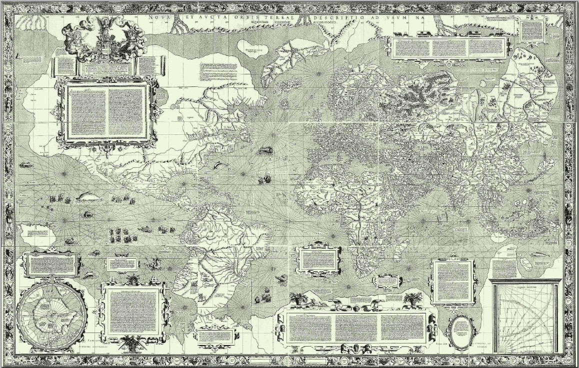
Early navigation map
Many experts say that this map, created by Gerardus Mercator, is one of the treasures of early maps. He attempted to mimic the curvature of the earth’s surface on a 2-dimensional representation. The image of this map shows that it was created for European navigators. Experts discuss the artistry of this map, as it represents some political conflicts from a distance—as if to suggest the minuscule nature of man compared to the incredible vastness of the world around us. It was this type of subjective representation that makes early maps a majestic historical document that speaks volumes about society at that moment in time.
Notable Cartographers the Helped to Build the Mapping Tradition
Early mapmakers had limited tools at their disposal but they managed with their early understanding of the cosmos, compasses, and zenith telescopes. Early cartographers then depend a lot on their imagination and their limited knowledge.
Fra Mauro
Mauro was a 15th-century Camaldolese monk who had a cartography studio in Venice around 1450 AD. His map is often considered one of the most well-known and beautiful pieces of medieval cartography.
Gerardus Mercator
Mercator’s map was mentioned above. In fact, Mercator may be a recognizable name to many. The Mercator map projection is named after this map maker. This was created as a navigational tool in the 1500s. It was Mercator’s attempt to accurately depict the Earth’s curvature and taking that into consideration for navigation that put his name on the historical roles of map-makers.
Land Surveyors, The Modern Map-Makers Working to Map Our World
The above is only scratching the surface of the amazing history of map-making and cartography. Today, we have amazing technology helping improve the process. Of course, maps and our interaction with them have changed considerably today. As Google attempts to find the “perfect map” land surveyors across the globe continue to do their job of measuring landmasses and establishing property lines, boundaries, etc.
Do you need property demarcation or a land survey of your property? Want to learn more about what we do? Connect with us at Land-Mark Land Surveying today.
How Land Surveying Influenced One of America’s Favorite Poet & Essayists
28 May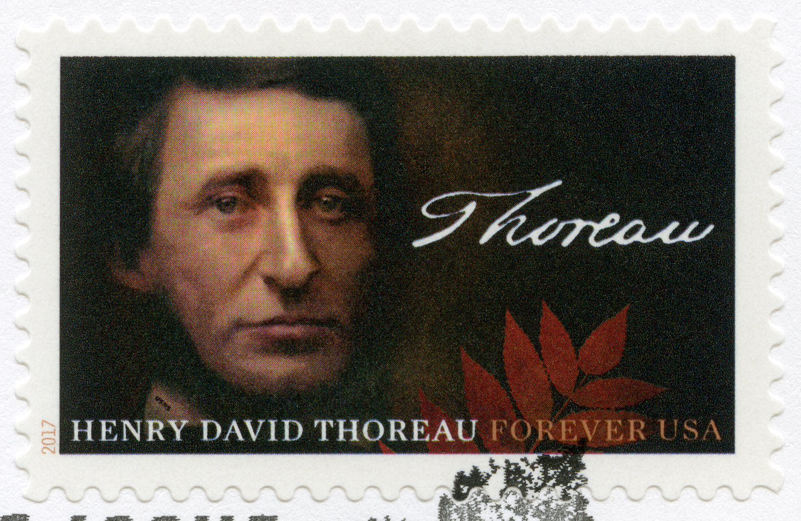
Many prominent people have gotten their start or dabbled in the art of land surveying. As we’ve covered in previous posts, well-known American figures have connected with the land through the art of land surveying. The work is ideal for those who see the beauty of the natural world. During the mid 19th century, America produced many memorable poets and writers that were essential in articulating and refining the American ethos and the philosophies of the New World. One name that is synonymous with harmonious living in the natural world — particularly as technology and cities began to grow— was Henry David Thoreau, known as an American environmental writer and essayist. When he wasn’t philosophizing and thinking profoundly about man’s relationship to nature, Thoreau was working as a land surveyor.
The Mark of Land Surveying on the Life of a Profound Thinker
Classical education in American history will likely come across the likes of Massachusetts native Henry David Thoreau and his work. With such well-composed life advice and profound thinking, Thoreau was known for his thoughts on capitalism, nature, and the individual. The son of a pencil factory owner, Thoreau became an apprentice to Ralph Walde Emerson—another big name in American literature. This meant that young Thoreau would be heavily steeped in the Transcendental tradition of his mentor. For the Transcendentalist, the way to a meaningful life was in the ability to hold oneself or maintain one’s separation from the material world and material wealth. This was an American delineation of the British Romantics, who saw the natural world as the arbiter towards spiritual transcendence and peace. Emerson wrote, “Mind is the only reality, of which all other natures are better or worse reflectors. Nature, literature, history, are only subjective phenomena.” This type of transcendentalist thinking was to inform much of Thoreau’s work, although he would depart from heavily discounting the power of nature on individual development. On the contrary, Thoreau put a lot more significance on nature and its presence in our lives.
Perhaps a little less known fact about the famous writer was that he was also a strong-minded abolitionist who participated in the Underground Railroad and railed heavily against slavery. During this time as a conductor at the Underground Railroad, he helped several slaves escape to Canada.
A Young Land Surveyor Uses Surveying to Inform His Work
As Thoreau worked parceling land that would be sold off to loggers. He used land surveying as his day job and dedicated himself to writing on his time off. He became Concord’s head surveyor in 1851. A close look at land surveying of the 19th century reveals that there were no licensing requirements to do the work. So land surveyors relied heavily on recommendations and their past work to vouch for them. Thorough was a man known in the surveying community as a man of integrity and this fared well for his ability to continue getting work.
The US Coast Survey formed in 1807 was important for the young land surveyor. The survey was conducted under the public spotlight and brought questions to the forefront about the role of science in democracy. These early surveys often had a significant impact on the shaping of society and people’s understanding of private property in the early days of the nation.
Land Surveying in the Mid 19th Century
The century has many important people working as land surveyors, but the work itself — done across the country — would help shape so much of America today. One of the most famous texts was the 18th-century treatise called “The Complete Surveyor or the Whole Art of Surveying Land.” This book was influential for other early surveyors including George Washington and Henry David Thoreau. The process of land surveying looked a little like this:
- The selling or distribution of the land to a prospective owner
- A prospective landowner would obtain a warrant
- A surveyor would go out to the location with the prospective owner
- They would mark out and demarcate the property line
- The surveyor would prepare a plat or special map of the boundaries
- The surveyor would include a textual description
- This document would serve as the deed to the land
The Long Tradition of Land Surveying in America
These figures have included the first president of the United States, George Washington, and founding father Thomas Jefferson. We have also covered the Lewis and Clarke expedition that gave way to a better understanding of the American Western frontier. The Lewis and Clarke expedition helped the American expansion efforts. In Europe at this time, land surveying would use a lot of transits, theodolites, and star charts, early surveying in the colonies used a different method that involved a long Gunter’s Chain to measure and demarcate the property. Most of the land surveyed east of the Ohio River was done using this method.
Land Surveying You Can Trust in the El Paso Area
Here at Land-Mark, we continue the great tradition of land surveying. The great predecessors of the industry have left behind great lessons of land surveying and much of their history.
As one of the Southwest’s most dependable land surveying firms, we are ready to help you survey your land with accuracy and reliability. Call us today and find out more about what we do.
The Evolution of the Land Surveyor’s Tool Kit: From the Romans to the 21st Century
26 March
Land surveys today benefit from hundreds of years of experience, knowledge, and tools. Our map creation of today uses anything from magnetic locators to special telescopes, to drones and satellites. The men tasked with early land surveys had simple equipment and employed special and innovative techniques to get the job done. As we saw in our series about Lewis & Clark, some of America’s most notable land surveyors, these early pioneers didn’t have much to work with but their knowledge of the land propelled them forward. Land surveys rely on smart techniques but also on their tools to get the job done.
Early Tools and Techniques for Surveying and Understanding the Land
Even ancient peoples had the urge and necessity to understand the land that surrounded them. It is an essential part of civilization—though not often discussed as such.
The Roman Groma
One early instrument in the history of land surveyors seems to have made its way from Mesopotamia. The Groma looks rather simple. It is a vertical staff with horizontal staff pieces at right angles. It was also adopted by the early Romans to measure land in the empire for taxation purposes.
The Greek Diopter
With the advancement of math and geometry came advancements in other fields. Land surveying advanced as the art of measurements and mathematical equations developed further. The Greeks developed the diopter. This was a lightweight portable tool composed of a cogwheel. They used water levels and astronomical features to survey a property. The theodolite—an instrument still used today— seems to have derived or at least been inspired by the early Greek diopter.
Land Surveying in Early Europe and American History
As Western civilizations expanded, the need to understand and record features of the land became more and more important. As the British Empire extended its borders across great lands, the explorers that led these expeditions sought to understand the lands in which they ventured.
In 1571, Joshua Habermel created the first theodolite. Modern versions of this tool still exist today and form part of the day-to-day surveyors kit. This is a precise instrument that requires a tripod and compass. When early Europeans began using the technique of triangulation, it improved the accuracy of the measurements of boundary lines. This early European method of triangulation was used up to the 1980s because of its simplicity and accuracy.
The Use of Celestial Maps & the Night Sky
In the mid 18th century, the theodolite was improved by the addition of a scope. Today’s Theodolite, for example, is a rather sophisticated telescope derived from these early versions. Surveyors around this time used sextants, which measured angles using celestial maps.
The Use of Other Early Tools
The land surveyor’s tool kit has evolved but the ideas have remained the same. Below is a list of various other early tools used by pioneer land surveyors that learned to be creative and innovative with what was at hand.
- Gunther’s Chain: This tool was around during the 17th century. It is a thin-looking chain consisting of a linked chain that is pinned to the ground and extended outward up to 60-65 feet. It helped surveyors define a path and record measurements from endpoint to endpoint.
- Gunter Surveyor Compass: Angles are critical for land surveys. Many of the tools that were developed early on focused on using angles to measure distances and terrain. Also known as the circumferentor, this tool helped determine right angles.
- Zenith Telescope: This is a refracting telescope and was pretty sophisticated for its time. It was designed to observe the night skies and contributed to the understanding of Earth’s rotation and axis. Portable versions of this telescope were used for land surveys including latitude determinations.
- Ramsden Theodolite: Jesse Ramdsen developed the Ramsden Theodolite in the late 1700s. He was an innovative London instrument maker that was tasked with creating an accurate instrument that used triangulation to divide England. The instrument weighed up to 200 pounds.
The Day-to-Day Instruments Used for Land Surveying Today
Most days it depends on the job. When surveying relatively flat terrain in the middle of a city to surveying mountain regions or deserts, there are various instruments and equipment that can be used. On any given day you might find your local land surveyor using the following:
- Surveying magnetic locators
- Surveyors safety vests
- Surveying tripods
- Marking paint
- Automatic levels
- Total stations
- Theodolites
- Electronic levels
The list goes on. Depending on the kind of job and the kind of survey that needs to be done, the tool kit may vary slightly.
Get Accuracy and Reliability with Land-Mark Land Surveyors
As experts in the industry, we have seen the development of many new technologies and equipment over the years. It is no substitute for knowing how to do the job. We pride ourselves on efficient and accurate work here at Land-Mark. From residential surveys to government contracts, we get the job done.
Need a reliable land survey? Trust the experts in El Paso and the Southwest. Call Land-Mark today.
America’s Most Famous Land Surveyors: The Journey of Lewis and Clark (Part II)
29 January
Surveying and map-making began as a treacherous and rather dangerous enterprise. It wasn’t for the faint of heart. Lewis and Clark were one of history’s most important land surveyors. They and their crew would be responsible for changing the course and expansion of America. In our last post, we explored the background of Lewis and Clark and some of the surveying tools that they would take on their journey. Today we continue our remembrance of this historic expedition and the surveying marvels that were born from this trek across unknown lands.
Two Surveyors, a Guide, & Thousands of Miles
In addition to their early surveyor tools like compasses, quadrants, telescopes, and chronometers, Lewis and Clark also gathered other necessary equipment. Some of these included weapons and ammunition, medical supplies and medicines, books on botany, geography, and astronomy, maps, as well as gifts to present to Native Americans they knew they’d run into including beads, face paint, ivory combs, and more.
The duo recruited 45 brave souls to join them on their way westward. Among these were 27 unmarried men, a French-Indian interpreter, a boat crew, and Clark’s slave known as York. One other unique characteristic about the Corps was the fact that it was a rather eclectic and diverse bunch. In addition to the Southern roots of Lewis and Clark, there was his slave, a one-eyed-part-French-part-Omaha-Indian fiddler player, a German named John Potts, and the famous Sacagawea, a Shoshone Indian.
Both Lewis and Clark knew the journey would require incredible tenacity and discipline and so they ran a tight ship.’ Historical accounts describe how the corps was led with an iron fist, including harsh punishments like bareback lashing and hard labor for dissidents or uncooperative members of the team. It is the ultimate adventure story, only one person of the crew would die during the journey—a 22-year-old who died of an abdominal infection.
The team headed northwest along the Missouri River. Thomas Jefferson tasked them with several missions and goals for the expedition. These included finding and mapping a route across the continent, making detailed observations and notes regarding the natural geography, landscapes, and natural resources out West. At the same time, the team was meant to establish good relationships with native peoples along the way to interrupt the British dominance of the fur trade in the areas.
By mid-October, the expedition had reached the Mandan villages on the Missouri River. This important trading place allowed them to make some connections and talk to others about possible routes westward. The team had moved to South Dakota, North Dakota, and Montana. From the Mandan Villages, the crew was now facing the Rocky Mountains, the highest mountain range. One famous story was of Merriweather Lewis falling 20 feet into a cavern, was poisoned, and then shot in the thigh.
The now-famous Sacajawea, the wife of one of the Frenchmen in the expedition, proved to be invaluable for the success of the journey, as her language skills and knowledge of the territory proved essential. By the winter of 1805, they had reached the Columbia River and made a transcontinental crossing north of Mexico.
By the end, the expedition has traveled about 8,000 miles while pushing, pulling, and hauling ‘the boat’, the famous keelboat of the Corps, facing harsh storms, weather, hunger, thirst, and one or two run-ins with bears, friendly and not-so-friendly Indians, exhaustion, sleeplessness, mosquitoes, venereal disease, dysentery, boils, ticks, injuries, and God knows what else. The crew also found themselves face-to-face with some elk, buffalo, and deer, which they kindly turned into campfire dinners.
Throughout the trek, many of the men kept detailed journals, which would serve them well, as many of the maps and drawings they tried to send back to Jefferson during their journey never made it through. Finally, the crew made it to the West Coast, moving through northern Montana, Oregon, and present-day Washington onto Ft. Clatsop.
The Land Surveyors Return Home to a Hero’s Welcome
When Merriweather Lewis and William Clark returned to St. Louis with their crew, they were celebrated as pioneers and heroes of the time. The crew arrived back in St. Louis in September. The Corps of Discovery go their own way, but Lewis is named governor of the Louisiana Territory, while Clark becomes an Indian agent for the West. Most of the intended goals of the journey were met. This included establishing diplomatic relationships with Native Americans. The crew held councils with Indians and participated in events with them. Upon his return, Lewis had identified 178 plants including bitterroot, prairie sagebrush, Douglas fir, and ponderosa pine. They had also identified 122 animals such as grizzly bears, prairie dogs, and pronghorn antelope.
A Tradition of Land Surveying Continues With Unprecedented Precision
Lewis and Clark’s journey is seen differently among historians. For many, the journey was one of the first tales of American exceptionalism and would spearhead a movement of westward expansion and discovery. Others focus on the tragedies that plagued the journey. In the end, the expedition’s contributions to early maps of American territory are indisputable. The flourishing country understood its terrain and natural resources much more in-depth than it did before 1804.
As land surveyors, we can only admire the skill and technical understanding of Lewis and Clark in their creation of maps. Their understanding of geography, astronomy, and climate, allowed them to make extraordinary conclusions that turned out to be quite accurate.
While the process is much different today, here at Land-Mark Land Surveying, we move forward with creating detailed and accurate land surveys for construction, government contracts, and more. Connect with us to find out more!
Where Technology and Infrastructure Meet
15 June Since 1991 Land-Mark has been at the forefront of the land surveying industry. A lot has changed since 1991, of course. In the early nineties, very few people could imagine that their cumbersome beepers would be transformed into sophisticated mobile devices capable of helping them navigate unknown territory (figuratively and literally), facilitate immediate communication across the globe, provide up-to-date news, take decent photographs, and store hundreds of bits of information. Similarly, technology has found its way to land-surveying and other relevant industries, providing equipment that increases accuracy and efficiency.
We use a variety of equipment, depending on the specific job, land, and project at hand. One of our trusted partners includes the company TopCon. These guys are highly innovative and perfectionists in developing new systems and equipment to improve the construction and planning of infrastructure and land planning. Topcon provides the positioning technology for surveyors, civil engineers, construction contractors, equipment owners, and operators. The geospatial solutions from Topcon have the most in-depth precision measurement for land mapping and surveying.
The Use of Digital Systems in Construction, Infrastructure, and Mapping
As land surveyors, Land-Mark is at the opening stages of a construction project. We form, however, part of the bigger picture that is all infrastructure building and construction. The use of technology in all stages of the construction industry has improved construction’s accuracy, safety, and efficiency.
In 1927, as TopCon points out, the world had 2 billion people. Only about one hundred years later did that number rise all the way to 7 billion. This means thousands of more acres developed, millions of more buildings erected, hundreds of more cities extended and expanded, and a constant and consistent demand for better and smarter building solutions.
A Few Amazing Examples….
Building great structures has always come at a human cost. There is not only a demand for human toil and labor but a high risk of accidents and injuries in any construction site. Any great building or structure you can think up has come at a cost of human lives. Some projects have been more successful than others. The Golden Gate bridge, for example, had 11 laborers died, a neighboring bridge, the Oakland Bay Bridge, had 28 people die in its construction. The World Trade Centers had 60 construction deaths. Recent technology, however, has allowed engineers to survey an area using drone technology without putting human lives at risk. A TopCon project to repair the Great Wall of China would have required workers to traverse a dangerous area. Instead, they sent a drone that was able to take thousands of high-resolution images that could then be input into a 3-D model, that was then used to examine the area and determine what needed to be done.
Measurement instruments have improved the ability for land surveyors like ourselves to enhance our workflow and improve our accuracy. Another great thing that technology offers is that added guarantee of accurate measurements and absolute efficiency. Land-Mark personnel is trained in a variety of high-tech and highly-specialized equipment that will ensure the proper mapping and measurements of your land project.
Explore the Wonders of Accurate Land Surveyors
So whether it is expanding a university campus in the middle of the growing El Paso central area or any other construction project in Las Cruces or Odessa, we are here to provide the most accurate topographic, stand land, improvement, and above and below grown surveying in the Southwest. Call Land-Mark today and find out more about our exciting projects in the area, both private and government work, that will show our dedication and find out about what we can do for your upcoming project.
The Path Forward: Understanding the Importance of Land Surveying
19 April Here’s a fun fact for you, did you know that three of the four presidents immortalized on Mount Rushmore were land surveyors? It’s true. George Washington, Thomas Jefferson, and Abraham Lincoln were all proud of land surveyors. It’s a beautiful thought; these men who basically build the America we know and love today also played their part in literally surveying America’s own land. The importance of land surveyors goes as far back as history immemorial. If you’re looking for land surveying assistance in the Southwest region, give Land-Mark Professional Land Surveyors a call!
What Goes Into Land Surveying
Although there have been many advancements in modern technology that have made land surveying as accurate as possible, the basic tenets of land surveying are the same as they were in Washington’s day. The measuring of properties and land in order to determine boundaries is as important in this day and age as it was back when the Louisiana Purchase first went through. Let’s say you purchased some land and you plan to develop said land. Before doing so, you must have it surveyed by a professional land surveyor. Avoiding this can lead to many issues in the future.
The Right First Step
Just imagine, you buy land, develop it, and build a shopping center over it. Then, a few years later, you find out the person who owns the plot of land adjacent to yours wants to develop it as well and a land surveyor determines you built on the neighboring land. This will undoubtedly lead to litigation and other legal issues you’d rather avoid. So, before breaking ground, hire a land surveyor. With their findings, you’ll be able to take the first steps towards building whatever you may have in mind. Even if you’re not currently planning on developing your land, it’s still a good idea to have it surveyed. This information will be incredibly useful, no matter what you plan to do with your land.
Putting Your Best Foot Forward
If you’re ready to partake in the century-long tradition of land surveying, then contact Land-Mark Land Surveying! We are the area’s foremost land surveying team which means our work is second to none. When it comes to land surveying, it’s in your best interest to not cut corners; the end result may be more harmful than good and you’ll have to face the negative ramifications further on down the road. Let our team survey your land so you can move ahead with your dreams, whatever they may be.
How Land Surveyors Shaped (and Continue to Shape) America
21 November Let’s transport ourselves to middle school history class. Do you recall the term “manifest destiny?” This was a 19th-century belief that the United States had a destiny (appointed by God) to expand across the entire North American continent. This was much more than a physical expansion of the nation; it was an expansion of the democracy and capitalism that was the foundation of the United States. Manifest destiny was much more than a belief, as it became a reality rather quickly. The Louisiana Purchase in 1803 doubled the size of the young United States, kicking manifest destiny into gear. Soon afterward, the famous Lewis and Clark expedition took place. Meriwether Lewis and William Clark were both land surveyors (amongst many other things) so they were the perfect candidates for such an expedition. This is just one example of the importance of land surveyors in America’s history.
How the Dominion of the United States Spread from East to West
The United States acquired large parts of Mexico in the early and mid 19th century. By 1846, we acquired the Oregon Territory thanks to a treaty with Great Britain. By 1850, the United States had grown to the size it is today. Fewer than 100 years after we declared independence from England, the United States ostensibly quadrupled in size. This is where land surveyors came into play. With so much land available, it was necessary for land surveyors to document each piece of the new America. Many land surveyors actually went on to become presidents of the United States. George Washington, Thomas Jefferson, and Abraham Lincoln all held the title of land surveyor. In fact, it was Thomas Jefferson who sent Lewis & Clark on their famous expedition of the Louisiana Purchase.
Land Surveyors Continue Making History
Although the days of early America are far behind us, land surveying still plays a major role in our modern society. Today, land surveyors pinpoint where your particular land begins and ends so you won’t accidentally build over someone else’s land. Surveyors are able to set boundaries as well. Many things have changed since the days of Lewis & Clark. Now, we’re able to use highly advanced technology to garner the most accurate readings. If you own land and want to begin developing it, make sure to speak with a land surveyor from Land-Mark Professional Surveying. We offer our services to clients in the Southwest regions of El Paso and New Mexico. When you partake in land surveying, you’re partaking in American history!
The History of the Boundary Survey
2 September Boundary surveys in El Paso identify the outer edges of a plot of land. The purpose is to make sure that the owner of the plot of land knows what pieces of ground are theirs and where their property ends. Land-Mark Professional Surveying, Inc. can provide assistance with boundary surveys in El Paso. The practice of surveying dates back even before people began building structures. Now, in the modern age, Land-Mark Professional Surveying can help.
History of Surveying
In 2,500 B.C., prehistoric surveyors set Stonehenge’s area with Peg and Rope geometry. Surveys, therefore, date back at least this far. When it comes to boundary surveys specifically, ancient Egyptians used to use simple geometry and a rope structure to conduct this type of survey. The rope structure and the geometric tools would re-establish the boundaries of lands after the Nile River flooded each year. In ancient Rome, land surveyors were professionals. With the developing of more tools, the modern surveying process began. And, in 1620, Gunter’s Chain was first introduced to make it possible for plots of land to be surveyed for both legal purposes as well as for commercial purposes. The long tradition of surveying began so long ago continues to this day.
Boundary Surveys in El Paso
And now, many years later, land surveys and boundary surveys are as important as ever. They are used for the same common reasons as they were back in ancient times. It is still as crucial as ever to have these important surveys done on your land. So, if you are buying, selling, or improving a plot of land, boundary surveys in El Paso will arm you with the information that you need to go into the transaction fully informed. We can provide you with the boundary surveying help you require. Contact Land-Mark Professional Surveying, Inc. today!