Land Surveyors: The Enigmatic Nature of Mapping Out Our World
21 November Land surveyors keep an ancient tradition alive. It’s true, land surveying extends far beyond the physical infrastructure. Everyone knows that the world is ‘connected’ today. When we use this phrase we usually refer to digital connections or avenues of communication across borders and oceans via social media sites or websites or access to the same or similar information. And while all that is true—that the world is figuratively more connected than ever—it is also true that there is physical work that is done in order to make these ‘connections’ possible. At the same time, the construction work we see on our way to work, the roadblocks that have us follow detours, all begin with an understanding of the land that is being built on, manipulated, changed. The work before the work is, in some ways, what makes land surveyors enigmatic and somewhat mysterious.
The Building Blocks—Geometry and Ancient Civilizations
Let’s take a step back in time. The concept of surveying or inspecting the land goes way back into civilizations. The division, understanding, and assessment of land serves many purposes and was used as far back as the ancient Egyptians for the purpose of taxation. Early surveys, used different types of instruments to gauge the dimensions of plots of land. According to Purdue University, in 120 B.C the Greeks developed geometry, although there were early versions of it in Egypt. Interestingly enough, the word Geometry means to ‘measure the earth’ and is the science of shape and size of things. Naturally, the science was then used to divide the land into shapes and plots, especially as civilizations grew, governments were established, and personal property needed to be measured and, yes, of course, taxed.
It was in Greece that the first piece of surveying equipment was developed. This was called the Diopter. This instrument was a mobile tool that used a cogwheel and water level to measure terrestrial and astronomical figures on a property. With this tool, the Greeks also developed a standardized method for surveying and basically created a protocol that set the stage for the process for many years.
And on to Europe and then the Industrial Revolution
You might remember a word or two about William the Conqueror from early history classes. Also affectionately known as William the Bastard, as his illegitimate birth was certainly a topic of conversation among royalty circles during his reign (his father impregnated a mistress), he ruled England from the time he was eight years old. Interestingly enough, William the Bastard’s reign was plagued with violence and turmoil, but he managed to maintain control and—despite not knowing English and being illiterate— made great contributions to the development of the English language in early England. He also made a great contribution to land surveying when he ordered a “Domesday Book,” a record of people who owned land in England and the sizes and shapes of their plots. This book placed a great emphasis on demarcating privately owned land and property.
The demarcation of personal property today—and if you are a property owner, then you are highly aware of this— is key in maintaining order and proper city records and plots. In 1571, the first theodolite was created. This was a more precise instrument, as compared with the diopter that came before it. The setup uses a tripod with a compass and is able to create boundary lines. It wasn’t until the 18th century, however, that plots of land began being measured with precise maps of where each was located.
In the 1800s, land surveying became an actual profession. And as the surveying tools improved, the process became more and more important. This was largely due to the rapid increase in population and the growth of cities, roads, and railways. Suddenly surveying land and understanding the landscape on which we built was much more of a necessity.
Land Surveyors in 21st Century Texas
You ask most people what the role of land surveyors is and they might come up with a relatively good educated guess. Most folks, however, know little about the process or understand that it is present before anything can get built. It’s why the surveyor is a kind of ghostly and enigmatic figure that comes in before the groundbreaking begins and plots out the land and territory.
Still in the 20th and 21st centuries, land surveying uses the same basic principles and concepts that were started centuries ago. The development of certain technologies, such as GPS, laser cameras, precision instruments, GIS software, and terrestrial scanning makes everything that much more accurate and efficient.
Surveying the Seas: Internet Cables that Run Our Online World
Another way that these surveying concepts are at work is through the network of cables that connect us all. As the internet has expanded, so has the infrastructure that supports it—even though it’s not often visible. It’s just another arena where the concepts and tools of land surveyors come into play. Fiber optic cable is laid out across the ocean floor to help connect people online. This is often referred to as the secret network that connects the world. It used to be that communications happened through copper cables and electrical signals. Today fiber optic cable that is laid across the land and ocean floor allows for the faster and secure communication we enjoy today. These fiber optic cables are often as thick as a human hair and carry pulses of late that transfer data.
Get An Accurate Land Survey with Land-Mark or Find Out More
At Land-Mark, we take the art of surveying very seriously. We have been in the business for many years and focus on providing accurate readings and maps of the land in question. Whether it is a government contract or a private enterprise looking for their next commercial location, accurate readings of property markings and coordinates are key in protecting yourself down the road from any legal troubles.
A Land Surveyor’s Tool Kit: What We Use in The Field
21 August
As land surveyors, we have to carry around a great deal of equipment. We’re often mistaken for photographers because of our tripods, but the rest of our gear quickly dispels that thought. We deal with precise measurements, so it’s crucial to have the right tools on hand. Here we’d like to teach more about our equipment, so you can see us and not mistake us for dedicated Instagram photographers.
- Theodolite – A theodolite is a surveying instrument with a telescope for measuring horizontal and vertical angles. Some land surveying crews use transits and total stations as well, which are used for the same purpose. These can be very pricey; they can range from $200 to over $50,000 in retail price!
- Surveying Tripod – Be sure not to spend all your money on the theodolite, because it needs a place to sit as well. The survey tripod is a sturdy tripod that is designed to move as little as possible for accurate measurements.
- Hand Tools – Besides the main equipment, a surveyor will need a host of other equipment to do the job well. Rope and measuring tape are great for rough measurements and marking, while items like picks and saws help clear debris to properly survey.
- Clipboard – All the data needs to go somewhere, right? A clipboard and pencil are necessary to take measurements or notes down onto paper, or a good PDA would suffice as well.
Land Surveying Done Right
If you’re in need of a land survey, Land-Mark Professional Surveying is the best in the southwest. We work in Texas, New Mexico, and Arizona, and provide quality land surveying for all of our clients. Contact us to see what we can do for you!
Land Surveying: The Best First Step You Can Take
15 July
 For many people, owning land is a lifelong dream. If you’ve achieved this dream, you need to look into land surveying services before you break ground and start construction. This way, you won’t face any nasty legal battles in the future. You see, avoiding surveying your land can cause adjacent landowners to seek legal ramifications against you, which can quickly turn your dream of being a landowner into a nightmare.
The Best First Step
When buying land, most people have a somewhat vague understanding of where their land’s borders are. The land seller might’ve said that the land is a few acres across, but how are you to know exactly where your land ends and your neighbor’s beings? This is where we come into play. By using state-of-the-art technology, Land-Mark Professional Land Surveying is able to provide the most accurate information so your dream can proceed without a single hitch. Our services are reliable. In fact, countless individuals and companies alike rely on us for all their land surveying needs.
It’s Time To Get Started!
So, if you’re ready to get started on the right foot, give us a call! We always strive to offer top-notch service to our clients. In fact, we also love talking about our services and processes so you can be as enlightened in the art of land surveying as us! Nothing should stand in your way when it comes to achieving your dreams. Contact Land-Mark Professional Land Surveying today.
Are You Dealing With a Property Dispute? Land Surveying Can Help
24 January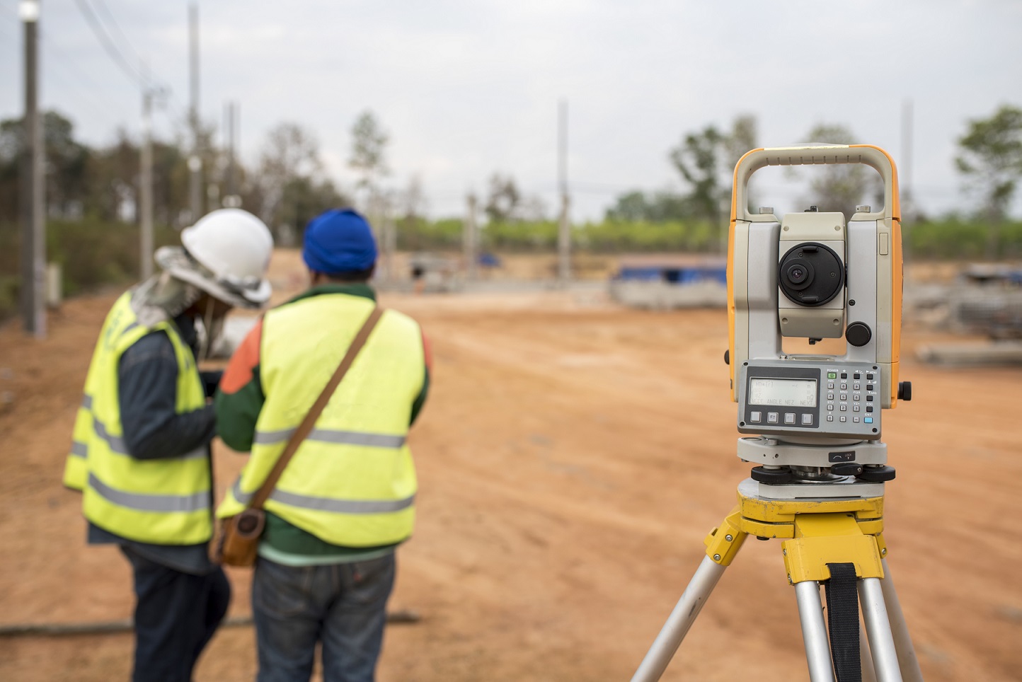
While there is typically a fence or barrier that tells commercial property owners where their land begins and ends, when a conflict coming from their neighbor arises, it can be complicated or downright impossible to settle the dispute. Many times these invisible borders aren’t enough to determine where one property owner’s land begins and where the neighboring property begins. This is where land surveying comes in.
Common Property Disputes
It’s often assumed that when you purchase a piece of land there exists a boundary set in stone. Although this is often the case, in some cases, such as with a change of ownership, the new owner can come in and request to place a wall or fence along his property. It’s common courtesy to speak to the neighbor prior to making any changes but it’s not required. If the neighbor sees an issue with the new fence or wall, he or she can argue that it’s obstructing or interfering with his or her piece of land. They can say that it’s interfering with their view or preventing others from seeing their property, creating a blockade if you will. Moreover, land disputes often come about when property owners decide to make additions to their building such as spreading out the parking lot, adding a front entrance, or extending their offices.
Requesting a Land Survey
Bringing in an unbiased, independent party will help meddle the constant bickering. Who wants to live this way, anyway? A land surveyor will conduct a physical lot line assessment and mark the boundaries that are in accordance with the local, state, and national guidelines. Although many times the land survey provides answers from a legal standpoint, if the issues get out of hand, the land survey can be court-ordered. The goal is to provide answers and have them solidified from a legal stand-point.
Why It Matters
Owning a piece of land is a huge investment. As the owner, it’s important that you do your part to protect your land. A land survey is the best way to provide answers and set the record straight. Even if your neighbor has already put up a fence, you still have the right to dispute the area it currently occupies. Lot line conflicts are quite common, which is why land surveyors are ready to settle the arguments.
Contact Land-Mark Professional Surveying
For professional service, contact Land-Mark. We’re licensed in Texas, New Mexico, and Arizona. As experienced land surveyors, we’ll provide the tangible and legal answers you need to keep your property protected. Connect with us today to learn more!
A Few FAQs About ALTA Land Surveys
18 May If you are buying a piece of land in Las Cruces, you have probably been asked by the bank or titling company for an ALTA survey. You may be irritated that you need to obtain such a detailed land survey, but this document provides a wealth of info about the property at hand. It may be more costly, but it is an excellent document to have to avoid issues later on down the line. We have answered a few frequently asked questions about these specific surveys here.
Why Do I Need an ALTA Survey?
This land survey is quite detailed, as mentioned before. It can be a bit more costly than the average land survey, but with reason. Title companies as well as lenders may ask for this survey. It can happen either when you are buying, selling or refinancing a property. Most often times, lenders are looking to avoid “survey risks.” This can include disputes over boundaries, encroachments and other difficult issues that can lead to problems and even lawsuits down the line. An ALTA Survey would reveal any of these issues and more. Even if the bank or titling company doesn’t require you to purchase this detailed survey, it may be advisable to avoid problems. This can be especially true when purchasing vacant land that has never been surveyed, or has been survey over a decade ago.
Why is an ALTA Survey More Costly?
Some land buyers in Las Cruces may be unhappy with the higher cost of an ALTA Survey. However, this type of survey is only performed by a registered, licensed surveyor. It means specific standards outlined by the American Land Title Association (ALTA) and the American Congress of Surveying and Mapping (ACSM). In essence, this survey meets the highest standards recognized throughout the U.S. It includes much more detail than most other land surveys. This can include boundaries, fences, utility lines, roads, easements and areas that have been improved.
How Do I Get Started With a Land Survey?
Getting started with any kind of survey in Las Cruces is as simple as calling us up at Land-Mark Professional Surveying, Inc.. We are one of the best and most reliable land surveyors in the Southwest. We provide a wealth of services to help you with your property. Whether you are buying, selling or refinancing a piece of land, our certified experts can help. Contact us today for more info.
What a Land Surveyor Can Tell You About Your Property
28 December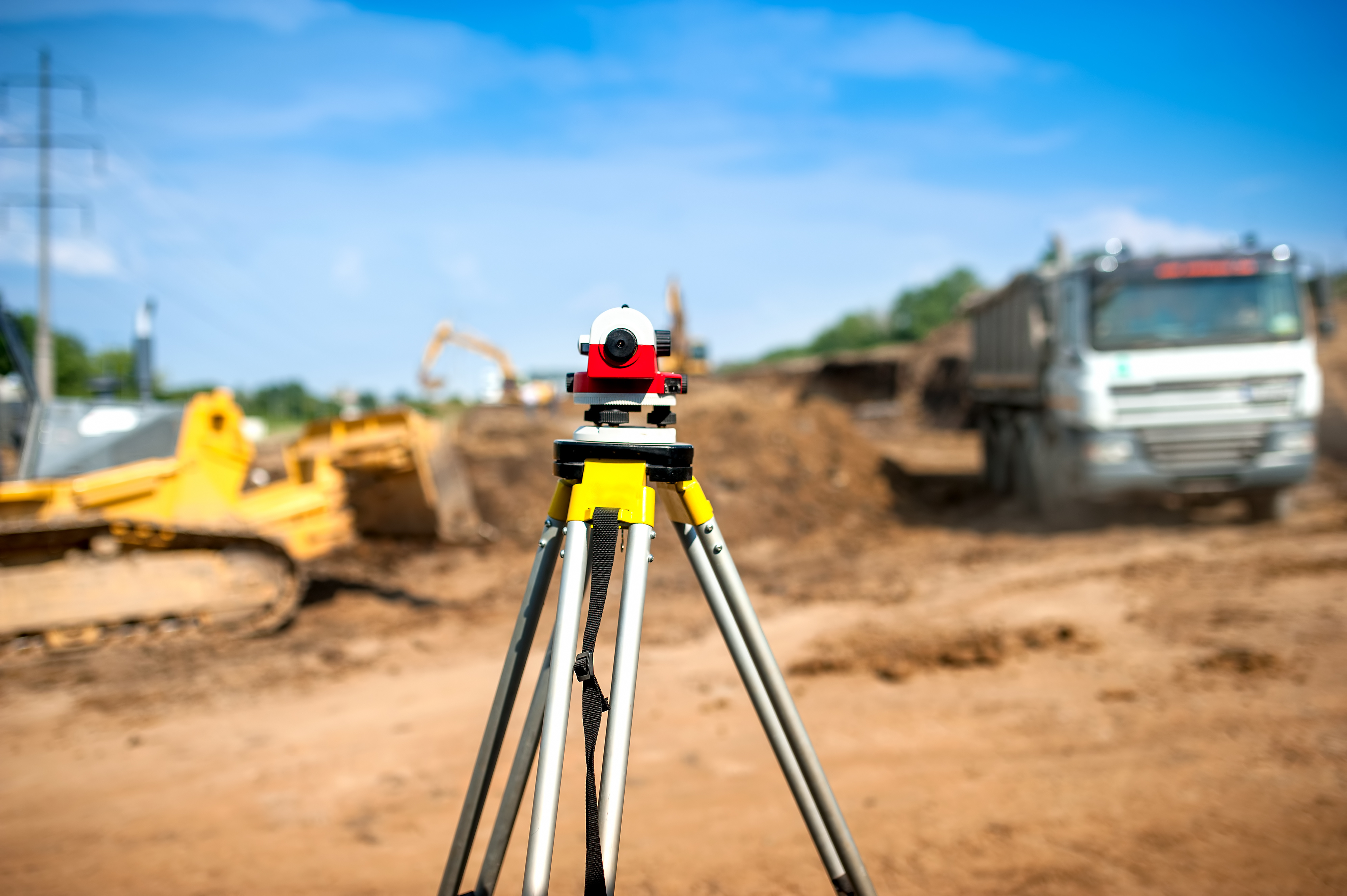
A land surveyor has a wealth of information available and can tell you extensive details about your land. If you are considering doing any developments or making any improvements to land in Las Cruces or surrounding areas, you need to get a surveyor to help you first. Land-Mark Professional Surveying, Inc. can provide all of the information that you need to be fully informed on the features of the land you own or are considering purchasing. A survey also offers great information for selling land.
What Can a Land Surveyor Tell You About Your Property
First and foremost, a land surveyor can tell you what the boundaries are on your property. You need to know exactly what plot of land you own in the Las Cruces area so you do not accidentally put any of your improvements onto property that is owned by someone else. Knowing boundaries is essential when land is sold. It’ also useful info if there is a dispute over who a given portion of a property belongs to. A land surveyor can also tell you much more than just where the boundaries are through.
A surveyor can tell you where easements and encumbrances are. You will also find out where the city has placed utility lines, what improvements previous owners made to the property. With certain types of surveys you can also find out what a property’s elevation is, and what the topographical features of a property are. All of this is essential because you don’t want to end up digging into utility lines, encroaching on easements, or unexpectedly purchasing a house or locating a building in a flood plane.
A survey for Land Planning
There will always be opportunity for city growth it is just a matter of defining where it is possible to grow. Sure there might be a lot of available land, however not all of it might be usable land; there’s where land planning comes in. Land planning involves a series of steps and procedures to determine if the land in question is a good fit for the client. You will also find out whether it’s a residential, commercial, or municipal client. The first thing to assert would be the quality and sustainability of the land. To do this, there are a series of surveys that can be done.
Landmark Professional Surveying Inc. offers a wide variety of surveys to provide you with the most accurate and up to date information about the land. You can purchase topography surveys, boundary surveys, and ALTA surveys (for inherited lands). A surveyor can also conduct land improvement surveys, state land surveys, as well as elevation certificates and right-of-way maps.
Getting Help from a Land Surveyor
Land-Mark Professional Surveying, Inc. is here to help if you need an experienced land surveyor. Las Cruces property owners and those considering purchasing property in the area can contact us any time. We will be happy to schedule a survey to obtain detailed information about a given piece of property.
Why You Should Always Hire a Land Surveyor for Land Transactions
20 December You need to hire a land surveyor Odessa if you are going to be entering into any transactions. If you are selling a property, you may need a survey to know exactly what belongs to you and where the property lines are. You don’t want any unexpected surprises when it comes time to close the deal and you find out the sale can’t close because the title search shows you don’t own the whole property. You also need to hire a land surveyor if you are going to be buying a property so you will be aware of the complete bundle of rights you are acquiring. The good news is, Land-Mark Professional Surveying Inc. makes it easy to hire a land surveyor and get a survey done right.
Why Hire a Land Surveyor Odessa
You should hire Land-Mark Professional Surveying Inc. to make sure that you know where the property lines are so you don’t build on a neighbor’s land. You also need a surveyor to help you understand where utility lines and easements are on the property, and to assist you in exploring the topography of the property in-depth. If you are going to be buying a property by using bank financing, the lender will likely require a survey from a professional to protect their own interests. Which means you may have no choice but to hire a surveyor if you want the sale to go through. If you plan to develop land, you’ll also need a survey to explore the best sites for development and to address issues like drainage.
Surveying Your Land
We have been in business for over 25 years serving the Southwest area. Our clients consider us one of the most dependable and sought out companies for land surveying in the area. We have the experience and expertise you need. When you are ready for a professional land survey Odessa contact us. Call Land-mark Professional Surveying Inc. to find out how we can help you.
Deconstructing the Elements of Construction Surveys
22 November
If you are curious about what is involved in construction surveys, hopefully the following information will serve helpful in breaking it down. Clearly the Las Cruces area has been growing in recent decades. This is mainly due to an influx of retirees and government employment. With this increase comes the need to build roadways and new structures capable of withstanding the demands of environmental and human engagement. Our company, Land-Mark Professional Surveying Inc. is comprised of professionals in the land surveying industry, ready to perform the first step in new building plan developments.
Construction Surveys Made Simple
It is important to understand the basics of surveys. Construction surveyors are land surveyors who have specialized training in the field of construction. It is also vital to remember that most construction projects can’t start without a survey. The surveys provide invaluable information that you can’t be see by simply looking at the land. This type of surveyorship is used to analyze the reference points necessary to guide construction. These points are then used to establish the best place for new highways, bridges, buildings, pipes etc. to exist. Preliminary construction plans will show various views of the project.
They will include views from above, transparent views and cross-section views. These different views help the construction project remain accurate during every phase. Once the surveyor has conducted the survey thoroughly, developers refer back to it during construction in order to verify correct application. Afterwards, engineers will conduct an “As-Built” survey to ensure the specifications set on the plans match the final outcome.
Professional Land Surveyor Services
The process of construction surveys in Las Cruces plays a vital role. When it comes to developing an expansive construction project you will definitely need a surveyor. Many individuals rely on this accuracy given their daily interaction with these new roadways or structures. At Land-Mark Professional Surveying Inc., we make it a priority to examine a construction project with the highest level of accuracy and professionalism in the industry. If you would like more information on construction surveys or how to have one performed for your next project, contact us today!
Selling? Here’s why you need a land surveyor in El Paso
8 November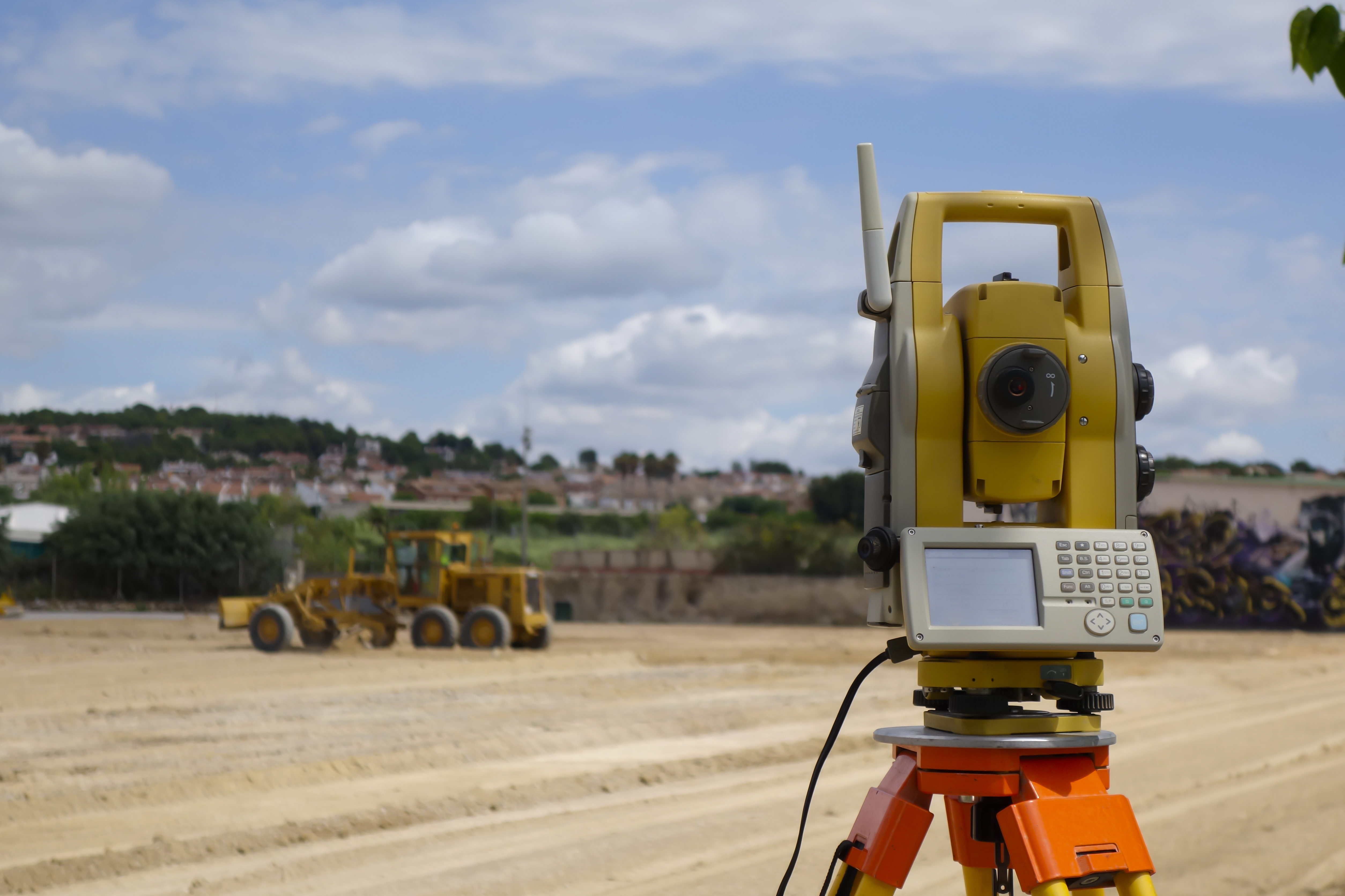
A land surveyor is hardly a thought when it comes to selling a home in El Paso. Getting this work done before you move away and hand the title of your house to another owner would be a wise choice. A land survey is a legal document created by a land surveyor. It will give detailed information about the land and it’s boundaries. prerequisite to make sure there’s no issues. Experts like LandMark Professional Surveying, Inc. will be by your side through this process because they are the experienced land surveyors who understand how to get the job done quickly and efficiently in an affordable way.
Benefits of Hiring a Land Surveyor
If you are selling property without any buildings, it is still a great option to hire a surveyor to conduct a land survey. As a seller, this will benefit you greatly, because you will gain a better understanding of your land. You may be underestimating the value of what you are selling. Secondly, if you are buying a piece of land that hasn’t been surveyed, you may end up finding out the clear boundaries. The last thing you want is to purchase the property and then find out it was smaller than you expected. Obviously, everyone involved in any kind of El Paso real estate transaction wants to know exactly what they’re getting and selling for their money. But there is more to getting a good land survey done in the El Paso area than just that.
An excellent land surveyor will not only mark the boundaries of the property that you are buying and sel ling, they will be also be able to supply a variety of other services including a topographical survey. A professional land surveyor in El Paso like LandMark Professional Surveying, Inc, provides not only info about boundaries are but also how the property they are buying slopes and in what direction. This is helpful in case they are considering building a house or commercial property. It is that kind of extra info that is important to make sure you build in a location that the water slopes away from the foundation of the building after a good rain.
LandMark Professional Surveying, Inc.
Our company is trusted by many El Paso, Las Cruces, and Odessa residential and commercial property owners. This is due to our staff exercising the highest standards of surveying according to Texas, New Mexico, and Arizona laws. We maintain timely delivery of jobs requested. If you want a land surveyor with accuracy and expert knowledge we are here for you. Please contact us today.
Top Reasons You Need a Land Surveyor in Las Cruces
1 November
Many people who buy or own land in Las Cruces will need a land surveyor. If you need a land surveyor, it is important that you find a competent and qualified professional. You want someone who can conduct a survey and give you accurate results. Landmark Professional Surveying can conduct many different kinds of surveys for different purposes. Some of these include surveys of land you own or are thinking about buying. Please contact us to find out about the services we offer and to see if you need the assistance of a land surveyor.
Why Would You Need a Land Surveyor?
Land surveying is the measuring and mapping of a specific location utilizing specialized tools, technology, mathematics. Some of the special technology includes GPS, Theodolites also known as Robotic Total Stations, and terrestrial scanners to map out the environment. In an office setting special software is used as well. Throughout Las Cruces, there are many reasons why landowners or buyers will employ a land surveyor.
One possible reason is you need to due your due diligence before making a land purchase. If you plan to buy a plot, you want to know as much about it as you can. You want to know boundaries, topography, and whether there are any improvements on the land. A surveyor can tell you all of this. If you are going to be developing land, this is another top reason why you need a surveyor. You cannot develop the land properly until you know what the conditions are on the land and have a good idea of what you are working with. Finally, you may need a land surveyor because your bank advises you to get one. A bank which is providing a mortgage for the purchase of land or a loan for the development of land is usually going to require a survey be performed before money is loaned.
Working with a Land Surveyor
If you are buying or developing land in Las Cruces, you need a good land surveyor. You want to make certain the surveyor has impeccable credentials, especially if your bank is requiring the survey. Our experts at Landmark Professional Surveying conduct many different types of surveys. We have the background and reputation necessary to ensure we do the survey process right. Contact us today to find out more.