What is Aerial Surveying and What Is It Used For?
23 March
Land surveying has come a long way. Old-time land surveyors used to rely on outdated equipment and methods that often resulted in inaccurate readings. Today, however, the equipment and methods used in land surveying are modern, highly accurate, and comprehensive. There are methods utilized today that were impossible for original land surveyors. One of these many methods that are even more advanced than the rest is aerial surveying. If you’re curious and want to know more about aerial surveying, what it is, and how it’s done, you’ve come to the right place.
Do you require land surveying in El Paso, Land-Mark Survey can help. Contact us online or call (915) 598-1300 to set up an appointment today.
The Basics of Aerial Surveying
As the name indicates, aerial surveying is when you conduct land surveying services from above the ground. Aerial surveying is growing in popularity because it provides a comprehensive overhead view of the property being surveyed. In most cases, aerial surveying is done using a drone, but it can include other methods, such as planes and helicopters. Contact us to learn more about the Landmark aerial surveying process or to schedule an appointment.
Advantages of Aerial Surveying
Aerial surveying is a great option for land surveyors offering several advantages as opposed to other types of surveying.
- Cheaper
Traditionally, aerial surveying was only possible if you had access to a plane or helicopter. This proved expensive, time-consuming, and inefficient, but it was sometimes necessary to complete a property survey. Nowadays, however, most aerial surveying is performed using drones, which makes aerial surveying very affordable, quick, and efficient.
- Better Overview
An overhead shot will almost always provide a property survey’s best overview and angle. You’ll be able to see things from the air that you simply can’t see from the ground or a high vantage point. It’s also the best way to see the property in question as a whole rather than in individual parts.
- Increased Access
Aerial surveying also offers access to certain areas that you simply can’t survey from the ground. This includes old buildings that are inaccessible, cliffs, mountains, and other rugged terrains inaccessible by car or foot.
What is Aerial Surveying Used For?
While you can use aerial surveying for any type of property survey, it’s best for surveying wide swaths of land. Aerial surveying can be performed in a single swoop or trip, whereas traditional surveying would take several trips and lots of manhours to perform, depending on the size of the property in question.
Aerial surveying is also a good option in high-traffic areas with lots of pedestrians, vehicles, and other obstacles. This includes properties near freeways, roads, highways, and cities. Here’s a quick breakdown of the industries and instances where aerial surveying is utilized the most.
- Construction and infrastructure projects covering a lot of land
- Surveys performed near busy highways and populated cities
- Monitoring construction site progress
- Property surveys of farms and ranches
- Property surveys located near mountains, rivers, lakes, and other inaccessible areas
Different Types of Aerial Surveying
As we said before, there are several different types of aerial surveying depending on what you need.
- Airplane and Helicopter Surveys
Airplane and helicopter aerial surveying offers the land surveyor a firsthand view of the property they’re surveying. However, these types of surveys are quite expensive and may require several passes.
- Drone Surveys
Drone aerial surveying is the most common type of aerial survey used in the land and property survey industry. Drones can capture overhead photos of the property in question, which are then uploaded and comprehensively viewed for surveying purposes. This is the cheapest, fastest, and easiest form of aerial surveying.
Who to Contact for Aerial Surveying in El Paso
If you’re looking for aerial surveying services in El Paso, look no further than Land-Mark Survey. We’re one of the top property survey companies in the area and can perform various types of land surveying in addition to aerial surveying. Contact us online or call (915) 598-1300 for a full list of services or to schedule an appointment.
The Amazing Drone Technology that is Revolutionizing Land Surveying
29 September Technology continues to change the way that we live, interact, go to school, go to work, build, fight wars, and more. Technology of one sort or another seeps into every sector of life and land surveying is no different. Most people will think of drones as a weapon of war and that’s certainly why they were first concocted, but the use and advancement of drones might actually have quite an impact on the industry of land surveying. The use of this technology is impacting our industry so we thought we’d pay a little tribute to the drone and its use in scoping out the terrain.
Drones During War Time
If told that the idea of drones goes back to the 1800s, most people would roll their eyes. Of course, drones as we know them today did not exist back then but the concept of sending unmanned vehicles to complete a mission happened when Austria attacked Venice with incendiary balloons they sent across the sky. These balloons carried bombs and were sent as a military operation. Without remote control, most of these balloons missed their target and did not actually drop the bombs where they were supposed to. Most wondered off, slowly descending with a dud, miles from their intended target. Now, compare that with today’s military drones and you’re talking about a whole different species, of course.
The U.S military began using drones more readily in the Vietnam War for reconnaissance missions and even dropping leaflets for psychological operations. Today’s drones are highly sophisticated flying machines that can capture photographs, information, and drop bombs at incredible accuracy and speed. Today, U.S military drones include a wide arsenal of flying beauties including the Reaper used to take out ISIS operation, the Shadow used for reconnaissance, surveillance, and field assessment, or the great Golden Hawk, which helped our great military in the Iraq and Afghanistan Wars. The Golden Hawk is known for its high-resolution surveillance capacities and the use of electro-optical and infrared sensors.
Drones or unmanned aerial vehicles provide the opportunity to navigate difficult terrain and reach difficult places without having to risk-taking vehicles or sending people up there. In this way, drones can offer access to hard-to-reach places and facilitate accuracy in mapping. When it comes to surveying land, drones provide eyes that can reach and hover over specific areas. Because of the remote control technology, height can be adjusted for better observation. They are also equipped with sensors and can measure and transmit data immediately. These drones can help in identifying property boundaries, subdividing land, and surveying of construction sites as they prepare for building. These drones can also produce accurate topographic and hydrographic maps, volumetric calculations, flood insurance maps, and more.
The world of civil engineering has long depended on manpower to gather data. Today, the use of drones is revolutionizing the industry of civil engineering and even construction because of its ability to gather accurate data for the purposes of building and more.
Drones in the Field of Land Surveying, Construction, and More
Drones are changing the land surveying industry in a couple of ways and provide certain benefits like:
- Disruption: Surveyors often have to deal with disruption or boundaries that make getting a full survey a little more difficult. The operator using a drone does not have to worry about any disruption to the sightlines.
- Imagery: Images collected from a drone are not only accurate but high resolution and can serve a variety of purposes.
- Risk: The use of drones lowers the risk to the surveyor when it comes to difficult and dangerous terrain, not to mention eliminates the need to go out when weather conditions are harsh and can disrupt the work. Because of this, the safety of employees and workers is prioritized. Land surveyors are tough and are used to navigating difficult places, but drones eliminate the need to put workers in unnecessary peril and get the job done with the same amount of accuracy, it’s a win-win.
- Survey speed: Using drones increases the rate of speed of receiving the information. Land surveying often requires carrying equipment and setting it up from one place to another. Drones can eliminate most, if not all of the need for this. Drone mapping means that you can do an entire area or construction site in one swoop and obtain accurate information.
- Efficiency and budget. As drones become more commonplace and specialized software makes its way to the civil engineering industry, using drones can be a way to stay in budget and make better use of resources for a project. And who doesn’t love that! Whether it is a construction company or a government contract, saving on resources is always at the forefront.
Mapping in Record Numbers
Experts assert that by using UAV (Unmanned Aerial Vehicle) technology will shorten the surveying process and contains the great possibility of reducing time and monetary investment. Whether it is the construction industry or home building industry, this is always on top of everyone’s list. The use of drones in surveying, however, is not just about productivity and speed, it is also about accuracy and the ability to improve the work we do. With this, we can carry out more projects in the same amount of time but also work with quality data sets, which in turn allows better and more through planning.
One popular example was the famous mapping of Ghost Ranch in New Mexico in 2015 that happened after the area suffered some flash flooding. Surveyors were called in to assess the area and get an idea of the damage and the conditions. An early company using UAV for surveying purposes was tasked to do the job and were able to do a complete drainage study with a 45 minute drone flight and mapped 1,200 acres in one hour for a stream geomorphologic study. Most people know Ghost Ranch for its contribution to such popular films as Indiana Jones, Cowboys and Aliens, No Country For Old Men, and more.
So as drone technology improves and becomes more ubiquitous, the work of the land surveyor will be positively impacted and improved. Here at Land-Mark, we are excited about the many possibilities that lie ahead with this and many new technologies. Until then, we continue to perform our work with high standards of excellence and accuracy for every job. If you need some land surveyed for a project, call us today and find out more.
The Beauty of Mapping Our World — From Maps to Land Surveying
30 March
We thought we’d go back this month, all the way back. What we do here at Land-Mark is to understand terrain and land for the purposes of historical records, construction, and more. All of that began, however, with the idea of mapping and what is known as cartography.
Understanding the terrain which we inhabit has been a natural impulse for people and therefore early attempts at mapping our surroundings appear early on in human history. The earliest maps date back to 16, 500 BCE. These maps, however, were focused on the night sky more than they were the earth itself. Ancient cave paintings often depict landscape features like hills and mountains. These early forms of maps were there to help people navigate the world.
In ancient Babylonia maps on clay tablets, as well as routes done by ancient Egyptians on papyrus paper. In fact, many ancient civilizations would come to develop their own systems of mapping and drawing out the landscape.
The Greeks
The Greek civilization was no different. They helped develop the industry of cartography as an important science. Many notable ancient Greeks would study the size and shape of the earth and its habitable areas, climatic zones, and country positions. We might all be familiar with Pythagoras, as he was the first one to draw the map of the earth that showed it as a sphere. Geographers of ancient Greece started trying to calculate the circumference of the earth.
Ancient maps are always fascinating, as they tend to be a little biased. Early Greek maps, for example, tend to show Greece as the center of the world. And this happened with China as well. Other early Greek maps, however, do show the landmasses divided into two continents: Asia and Europe. This was derived, in large part, by Homer’s work and other notable works of the time.
The Roman Empire
The Roman empire began to see a real practical and functional use for their maps. Understanding the terrain meant that this could help them for military purposes and other expansion efforts. The need for the empire to control and protect their empire in both military and economic aspects, meant that they needed to have a precise picture of boundaries and road networks.
Other important map contributions include the Ptolemy map, which is notable for its probable role in the Roman expansion. This is the beginning of latitude and longitude, which we still use today in all of mapping and land surveying. This was originally done around 130 AD but was lost and had to be recreated in 1300 AD. Cartographers that came after this then adopted this system and refined it to be far more accurate.
During the Middle Ages, where so much scientific and artistic advancement was halted, the work of map-making continued. Many Muslim scholars followed the methods of latitude and longitude. As travel across the glove increased, various notes and writing became essential to understanding the new terrain.
Later on, medieval European maps adopted their own form of doing things. They called them ‘mappa mundi.’ The largest Medieval map still in existence includes the Hereford Mappa Mundi—an elaborately and delicately colored map. The Fra Mauro map is another notable map of the ancients. It was created by a monk and it is a large round map of the world.
Let’s skip to the 1600s. There is the famed Ricci Map, a.k.a the Impossible Black Tulip—which is a great name for a map! This map was put together by a Jesuit priest and actually shows the Americas, though it has China in the center.
As Modernity Sets In….
As people continued exploring and mapping out the world, discovering new worlds, mapping those out and so on and so forth, maps became more and more accurate, necessary, and detailed. As the Industrial Revolution set it, trade and commerce began to connect the whole world through a vast network of trading routes and travel. This meant that a more defined understanding of our world was needed. All of a sudden, travel for pleasure was possible and people taking vacations or exploring new areas of the world were looking to move through the areas.
The ornate maps of earlier times, however, were replaced with far more functional and practical maps that could be used for various types of travelers including business travelers, explorers, and even leisure travelers. During the 19th century, railroads expanded rapidly throughout the world, connecting the world once again.
Reading maps is something that used to be taught in school, perhaps not so much anymore if most people use the GPS technology. Nevertheless, the world of mapmaking continues to be a fascinating field, as it is focused on providing detailed information about a certain terrain.
Find a Trustworthy Land Surveyor — A Different Kind of Map Maker
Here at Land-Mark Land Surveying, we don’t make your typical maps but we engage in the practice of creating detailed and informative depictions of a particular landmass or piece of land.
The Evolution of GPS Technology and How It Affected Land Surveying
28 January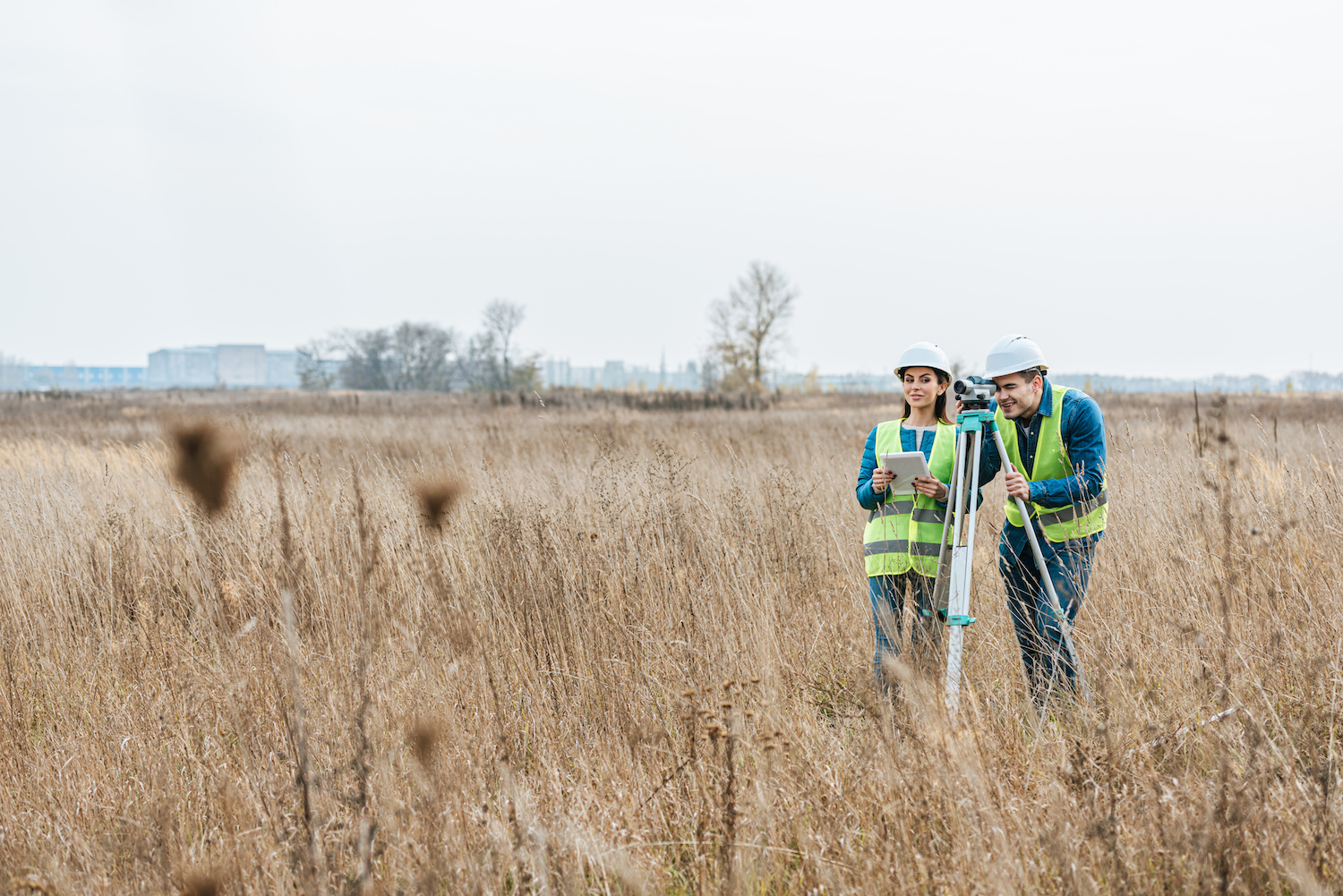 We live in the age of information. We all probably hear this phrase on a regular basis and are made of aware of this fact again and again when we encounter— and have immediate access to — endless bits of information and media and entertainment. Land surveying involves the gathering of information and data. The world of GPS has also significantly changed the way we travel and move around, as well as the way we understand the terrain. Many people now depend on GPS to get around. As land surveyors, GPS technology has impacted the way we do our work as well.
For centuries, scientists aimed to devise a way to enhance and improve our navigation and improve our ability to pinpoint our position in the world with accuracy. That technology exists today and most of us hardly give it a second thought.
The Beginning of the Technology
The GPS technology has so steadily snuck its way into our cars, our phones, and our lives. It has its origins in the Sputnik era. Scientists were able to track the satellites with shifts in their radio signals. This is known as the Doppler Effect. Throughout the 1960s the United States Navy conducted experiments to track submarines carrying nuclear missiles. In the 70s, the Department of Defense used some of this Navy technology and continued the movement of using satellites to track movement and for sophisticated navigation systems.
The DoD launched its first Navigation System with Timing and Ranging (NAVSTAR) satellite in 1978. By 1993, the 24 satellite system that GPS uses today was pretty much operational. There are two levels of service: the Standard Positioning Service and Precise Positioning Service. Access to the latter is restricted to the U.S Armed Forces. The former is the one most people know today as the GPS utilized by everyone.
So who created this technology and who do we credit as the inventor? After all, we always want to put a face to the name, even though some of the inventors we credit are not often the ones that deserve all the credit. Thomas Edison, for example, gets all the credit for the light bulb, but Humphry Davy might have something to say about that.
When it comes to GPS technology, there are a lot of people that contributed to what ultimately became the technology. There are four people typically credited with at least spearheading the concept that was developed by the US Department of Defense for military purposes. There is Roger L. Easton, the former head of Naval Research Laboratory’s Space Application was the brain behind a lot of the preliminary applications. Another name is Ivan Getting which contributed to the idea of using an advanced system of satellites to allow the calculation of data. Bradford Parkinson was at the forefront was also a chief architect of the technology. And then Dr. Gladys West also contributed to the advancements of calculations for an accurate model.
GPS stands for Global Positioning System and today this system has become quite sophisticated that it allows us to find addresses that might seem otherwise hidden or in the middle of nowhere. GPS uses signals from satellites to pinpoint a location on the Earth’s surface. GPS will use at least 24 separate satellites in a system that consists of six earth-centered orbital planes.
The Main Uses of GPS & How They Help Land Surveyors
- It determines a position or location
- Facilitates navigation
- Allows tracking
- Creates maps
- Aids accurate time measurement
How did GPS make its way into land surveying?
Because land surveyors are essentially marking and measuring terrain and property, GPS was a natural for the industry. The use of technology in surveying was one of the first commercial adaptations of GPS technology. GPS survey equipment allows the ability to obtain location, distance, and height almost instantaneously.
There are some pros and cons, however, when it comes to using/depending on GPS for land surveying. The benefits include:
- It offers a higher level of accuracy
- Calculations are made quickly
- Land surveyors can carry GPS components easily
There are also some slight disadvantages. These might include:
- Requires a clear view of the sky to receive the satellite signal
- When the area has intense foliage, there may be limits
- All GPS survey equipment is subject to failure
- The equipment can be costly
As GPS evolves, of course, land surveying will likely benefit and only increase its efficiency and accuracy. Already, in the last decade there has been quite a lot of changes in the way that land surveying is done, thanks to new equipment and improvement of techniques.
Get Accuracy with Land-Mark Land Surveyors
Just like any other industry in the 21st century, land surveying continues to change and advance as technology does the same. Here at Land-Mark, we do the job right. We use top-of-the-line equipment and the best techniques to ensure an accurate reading.
Land Surveying on Mars: Using Earth-Based Tech to Map The Red Planet
18 March The planet Mars has held the attention (and curiosity) of earthlings for decades. Ancient peoples, such as Greek and Romans, noticed the red planet and named it after their god of war (Ares for Greek and Mars for Roman). These ancient peoples had a knack for naming planets. The ravaged, cold landscape of Mars does look as if a terrible war on a planetary scale took place on its surface, eons ago. Today, half a millennium later, the planet continues to fill our minds with ideas for the future of mankind. What separates us from the ancients, however, is our ability to learn more about Mars than ever before. Thanks to modern advancements in technology, mankind has been able to gather more information about Mars than ever before. This red planet is being surveyed by rovers and, in the future, by drones. The age-old tradition of surveying will pave a way for humans to potentially make Mars our second home.
The Truth About the Red Planet
It may seem like the Greeks and Romans hit it out of the park when naming Mars after their god of war. The surface of Mars is the definition of desolate, much like a location after thousands of nuclear bomb has been dropped. But the surface of Mars is actually much colder than one might initially think. This all has to do with the planet’s relative location in our solar system. Earth’s location relative to the sun, for instance, is not too hot or too cold. Our neighbors, Venus and Mercury, are far too close to the sun and thus have surface temperatures of 864° Fahrenheit and 801° Fahrenheit, respectively. Mars, on the other hand, has more “livable” temperatures (at least, during the day). Temperatures during a martian day near the equator can reach around 70° Fahrenheit while temperatures at night can reach minus 100° F. Pretty cold, isn’t it? Earth, which is the third planet away from the sun is the perfect temperature for life to thrive. Thanks to Earth’s temperature, water doesn’t immediately evaporate. This is why there’s life on Earth, as opposed to the other planets that surround us.
How NASA is Preparing to Survey the Surface of Mars
But does this mean life never existed on Mars? Thanks to the handful of rovers that have traversed the red planet’s surface, as well as high-quality images from satellites and telescopes, scientists have been able to find frozen ice or even signs of long-dried out rivers on the Martian surface. Perhaps Mars was a green, flourishing planet eons ago but today we only see the cold, distant remnants of an empty planet.
NASA is currently testing the Prandtl-m prototype. This drone will survey Mars’ surface (much how land surveyors surveyed America and the rest of Planet Earth throughout history and today). It’s incredible to think that the long-standing tradition of land surveying will be used to depict the surface of Mars. With this information, Earth-based scientists will be able to formulate what it may take for mankind to live on Mars. Today, however, you can call Land-Mark Land Surveyors to take care of all your Earth-based surveying needs.
What Can I Do If My Neighbor Builds on My Property?
26 February
Imagine this: you’ve finally found that white-picket fence, American dream of a house that you’ve always wanted and dreamed about, and then…your neighbor starts building on your property. Whether it’s a fence that cuts into your yard or you find your neighbor pruning what doesn’t belong to him, property disputes with neighbors are actually quite common, especially when there aren’t clear barriers or lines denoting whose property is whose. Here are a few things you can do if you find yourself dealing with a property dispute.
#1: Start With a Civil Discussion
Many times, when property disputes happen, simply talking to your neighbor about it can oftentimes resolve the problem. But we know that isn’t always the case, especially when the borders dividing your yards aren’t so cut and dry. If a civil discussion doesn’t cut it, don’t fret because there are other options for you.
#2: Bring it Up With a Property Manager
If you’re renting your property, your property manager may be able to help you resolve the dispute, especially if they are renting out your neighbor’s property as well, as is the case for many neighborhoods in El Paso. However, we’ve seen that many property disputes happen between two people who own the home they live in. If that’s the case, obviously this step is one you can skip.
#3: Contact a Land Surveyor to Help
A land surveyor’s job involves surveying land to identify property lines, among other things. So, if there is a dispute between you and your neighbor, a land surveyor can help you identify where your property lines fall so you and your neighbor can build and install to your heart’s’ content without worrying about building on each other’s property.
#4: Talk to a Lawyer as a Last Resort
If all else fails, a lawyer can help you dispute the barriers as well using the information the land surveyor gathers about your property lines. It’s a worst case scenario but sometimes it has to be done.
The Importance of Land Surveying and Property Lines
Land surveying is important for all sorts of functions in life, from architecture and homebuilding to economics and landscaping. Land surveying can identify property lines, help people build and expand thoughtfully, and can help with things like habitat preservation. At Land-Mark Professional Surveying, Inc., we can help people dispute property boundary issues civilly. Call us today to learn more!
A Few FAQs for Your Land Planning
11 September If you are in the process of building on your land, you probably already know that the local government will want a site plan. You will more than likely need to enlist the help of a good surveyor for a land planning survey. On a good note, getting a survey done will also provide you with valuable info for your site planning needs. Whether it is a personal plot and you are building a home, or you are working on a commercial plot to build a retail center, it doesn’t matter! A survey can point out all the different aspects of your land that will impact your building plans. At Landmark Professional Surveying, Inc., we have a few FAQs here for your planning:
Question: Do I Really Need a Land Planning Survey?
Answer: First of all, your local government probably requires some kind of survey in order for you to obtain the proper permits to build on your land. But, as mentioned, land surveys offer valuable info for land planning, as well. This can include the type of ground you are building on, best areas for drainage, finding out if you are on a floodplain or hard rock, and so on. When you are planning buildings and improvements that interact with the land, a survey is always good to have, whether it is required or not.
Question: What Do I Need to Know About Land Planning Surveys?
Answer: First of all, your local survey agency will know the details of your required land survey for permit needs. They will have a firm understanding of what this legal document needs to provide. Not only will they create a proper survey to satisfy permit needs, but will provide info about your land for building purposes. From topography, property boundaries to proposed grading you can be sure to get a thorough account of your land.
Question: How Do I Get Started?
Answer: Getting started on your land planning needs and survey is as simple as giving us a call at Land-Mark Professional Surveying, Inc. We work with builders, architects, and government officials on a regular basis. We have a firm understanding that is drawn from 17 years of experience in the industry. We have provided services to private and commercial land builders in the Southwest region and offer reputable services. Give us a call today to get started on your land survey. We will be happy to answer your questions or set up a consultation.
Proper Land Planning for University Expansion
18 March When you are expanding a university’s campus in El Paso, there are some key factors you should be aware of for successful land planning and development. One of the most important elements in any building expansion is making sure you first understand the parameters and boundaries of the property. Conducting a thorough research of the property during the initial stage will guide all further building plans and budget costs involved.