The Latest Trends in Land Surveying
18 January
If you’re an El Paso land surveyor, it’s paramount that you stay up to date on the latest trends. Like all businesses, land surveying and land development constantly change and develop with time. New tools and tricks of the trade are expected to come out in 2023, and it’s up to you to be up to date on what they are.
If you require land surveying services for your El Paso home or business, the professionals at Land Mark Survey can help. Contact us online or call (915) 598-1300 to learn more about our services.
4 Land Surveying Trends to Watch Out for in 2023
The Use of Drones and UAVs
Drones and UAVs were first introduced to the land development industry several years ago. However, while they were once thought of as an option or backup plan, drones and UAVs are quickly becoming the future of land surveying. Drones and UAVs can cover massive areas, gain access to areas previously thought impossible, and provide in-depth information for surveying purposes.
Drones are now also capable of:
- 3D mapping
- photogrammetry
- topographic surveying
- Geospatial Surveying
- Mapping and scanning
- Environmental monitoring
- Many other things
These added features make drones and unmanned aerial vehicles even more prolific. Additionally, working with drones is safe and easy and can lead to increased productivity. If you’re serious about land surveying, you will do well to jump aboard the drone train. Or, if you want to avoid making the investment, you can contact us at LandMark Survey, and we’ll perform drone-related surveys for you.
Cloud Data Storage
Unless you’re familiar with all the data that goes with land development, you likely don’t realize how big of a trend cloud data storage is going to be. The files and documents that go along with land surveying are massive, which means that cloud storage is a huge improvement. This trend is being helped along with the increased popularity and availability of 5G networks.
Increased use of cloud storage for land development will also make collaborating and sharing with others easier. Surveyors, developers, and everyone else involved in the land development process are sure to gain from the cloud data storage trend.
Mobile Mapping
Mobile mapping is perhaps the most revolutionary land development trend to be aware of. With mobile mapping, land development would be faster, easier, and more convenient than ever. It would allow a device that fits into a backpack to do most of the work for you. An added bonus of 3D mobile mapping is the fact that scans would be quicker and easier to share than ever.
Continued Accessibility and Integration
The final trend to be on the lookout for in 2023 is the fact that land surveyors will have access to more areas than ever before. Thanks to all of the new and updated technology hitting the market, accessibility and integration are expected to be better than ever. Drones, mobile mapping, and the Cloud alone are making this possible.
However, even the hands-on tools and training that surveyors use are improving. When you combine these tools and continue learning with new technology, the sky’s the limit for land surveying.
What is the Future of Land Surveying?
The future of land surveying is bright as long as you can keep up with the coming trends. Surveyors that stay in the past and don’t acclimate to advancements in training and technology are doomed to get left behind. Therefore, you should stay up to date on all the latest land development trends.
Which El Paso Company to Contact for All Your Land Surveying Needs
If you’re looking for a land surveying team that can keep up with the latest trends, look no further than Landmark Survey. Whether it’s drones, UAVs, mobile mapping, cloud storage, or anything else, we’re up to the challenge. Contact us online or call (915) 598-1300 today for a complete list of services and to learn more about our process.
The Search for Shackleton’s Ship: The Man, The Myth, & the Land Surveying Legend
25 January
The early days of exploration are filled with eccentric historical characters that took incredible risks to venture forth into the unknown. The drive to be part of geographical and scientific discovery led many to treacherous lands. Explorers from Marco Polo (who traveled along the Silk Road) to Christopher Columbus (credited with discovering the new world’) and Ferdinand Magellan (the first European to cross the Pacific Ocean), the age of exploration was one of the exciting discoveries that would change the course of history and people’s understanding of the earth, its landmasses, its oceans, and its natural landscapes.
Through it all, these explorers took on the role of land surveyor, as they all made notes and observations of the lands and used early land surveying instruments to navigate and orient themselves.
This month, we go back in time to explore the story of Ernest Schakelton, a somewhat controversial and misunderstood historical figure.
The Heroic Age of Antarctic Exploration and the Men That Searched for Answers
During the late 19th century and early 20th century, Antarctica was (and continues to be to some extent) a mysterious muse that calls enticingly to the hearts of those with a dangerous proclivity for adventure and the unknown. During that time, Antarctica was a great mystery, one that promised a level of adventure to fulfill the innate drive of any curious explorer. The exploration of the “Tiera Incognita” was largely limited.
In 1895, a Congress meeting in London declared the exploration of the Antarctic continent as “the greatest piece of geographical exploration still to be undertaken.”
Ernest Shackleton, the Man
Like many discovery expedition leaders of the time, Shackleton has accrued a certain amount of ‘street cred’ in the long list of fearless explorers. Before he set sail for the unknown, however, Shackleton was the son of a doctor born in Ireland. In his early teens, his family moved to London. Already harboring an innate call for adventure, young Shackleton would defy his father’s wishes of following in his footsteps and going to medical school for a chance to join the Royal Navy. He was only 16 when he joined and qualified as a master mariner in 1898. He traveled extensively with the Navy but had a secret love for the promise of exploring the Arctic, which was all the rage at the time.
Ernest Shackleton, the Legend in the Making
In 1901, young Ernest Shackleton got his first taste of polar exploration when he was chosen to go on the Arctic expedition led by the famous Robert Falcon Scott. They set sail on the ship ‘Discovery’ towards the South Pole and got closer than any other expedition had before. The ship traveled in harsh conditions and met severe resistance, but Shackleton became gravely ill and had to return home.
About eight years after his first polar expedition, Shackleton returned to treacherous seas onboard the ship ‘Nimrod.’ On this voyage, his crew met some extraordinary circumstances, made some important discoveries, and climbed Mount Erebus. Upon his return to England, he was knighted.
The Endurance Sets Sail
In 1911, an expedition led by Roald Amundsen was the first to reach the South Pole. About a year later, another expedition led by Robert Falcon Scott also reached the South Pole, although without the knowledge that they had in fact been beaten by Amundsen’s party. Sadly, Falcon’s expedition perished on the return home. Amundsen’s expeditions, however, would bring back land survey data that would be useful to the scientific world including data that documented a great chain of mountains from Alaska to Patagonia. This ice barrier was believed to be a big obstacle to further Antarctic exploration.
The Endurance Expedition was tasked with crossing the Antarctic continent from one end to the other through the South Pole. Despite the widespread news of Robert Falcon Scott’s tragic end in his expedition, volunteers jumped at the idea of sailing to those treacherous lands. The expedition was set to set sail as World War I was breaking out. Shackleton himself offered up his ship for the war cause but was told to proceed with the expedition.
Once the Endurance set sail from a short stay in South Georgia where they collected provisions, the ship battled her way through thousands of miles of pack ice.
A Ship Stuck in the Ice
Then, the ice closed in around the ship. The ice around the ship gripped it tight and dragged it, drifting them further away from their intended course. The ship would be frozen in for the winter and one of two scenarios were likely to occur:
- The ice around the ship would melt in the Spring and set them free
- The ice would continue to put pressure on the ship and crush it
Meanwhile on board, the crew played hockey and sports games on the ice, trying to make the best out of a dire situation. Eventually, the situation led Shackleton to conclude that the ship was lost and they must abandon it. This meant the crew was floating on ice with no hope of being rescued.
The crew had to split up and Shackleton led a few men on a lifeboat to try and seek help at the nearest whaling station hundreds of miles away in South Georgia. It was a treacherous journey but the only hope. The men fought giant waves, cold weather, overcast skies (which hindered navigation) but they carried on. They managed. Once they made it to South Georgia, they had to cross mountains to reach the whaling station, another treacherous journey. They finally reached it and made their plea to go back and rescue the others. Shackleton did not give up on the remaining men and managed to get boats and help to go back and rescue half of his crew left behind. Not a single man of Shackleton’s 28-man crew was lost.
The Adventurous Spirit and The Advancement of Land Surveying and Navigation
The spirit of discovery and understanding our planet is still very much part of land surveying all over the world. In Feb 2022, an expedition led by advanced technological land surveying and navigating equipment will attempt to locate and find Shackleton’s lost ship.
And while we’re not out exploring the South Pole, Land-Mark Land Surveyors continue the tradition of land surveying here in the Southwest. We survey land before it is used for residential or commercial purposes. Call us to learn more!
Land Surveying in Harsh Environments: Helping Map the Mysteries of Antarctica
29 November
Human beings have done a lot of exploring since modern civilizations began and ships, automobiles, and airplanes allowed for the traversal across oceans and vast landmasses. There are still places out there, however, that remain to be fully understood.
Antarctica, the fifth-largest continent, with 5.4 million square miles, storage of the planet’s fresh water supply, and a variety of penguins, polar bears, and other animal life is still largely a mystery. Land surveyors, among others, are part of the group of people that have helped understand this amazing landmass little by little.
How do land surveyors work in such harsh environments? What is their role in the slow uncovering of Antarctica’s secrets?
Let’s survey some of the details.
Land Surveyors as Outdoor Explorers — How We Map Harsh Terrain
While many jobs adjusted to the covid pandemic and switched to remote or work-from-home models, land surveyors were doing anything but. Their job cannot be done remotely, nor can it be neglected or left to chance. Precision is everything in land surveying, as it contributes to the mapping and understanding of the landscape while being essential to the building of infrastructure. The United States Antarctic Program (USAP) is a government-sponsored program that represents the country in the region. The program strives to encourage international cooperation, maintain a presence in the region, and conduct quality science research there.
Well-known land surveyor Jeffrey Scannielo is part of a team that works in the Antarctic region. McMurdo Station is the U.S. station in Antarctica and is at the tip of Ross Island about 2, 415 miles south of Christchurch, New Zealand. Most of the field research and activities go through this station. Scannielo— a licensed surveyor in the state of Colorado— was working doing land surveying to help build runways for McMurdo. The runways are essential for planes landing and scientists, biologists, and other researchers to come in.
Scannielo explains part of his mission was monitoring the sea ice conditions for aircraft/vehicle safety. He had to do this in temperatures that raked below -62 F with wind chill. That’s a brisk day at the office! He explains how modern technology has helped land surveyors in dealing with the job in harsh environments such as this. Current GPS receivers, for example, have increased field productivity. The equipment today is efficient, stable, and resilient, which helps when you’re dealing with icy conditions.
Land Surveyors in Antarctica — Just Another Day at the Office
When land surveyors work in the United States, there are a series of tools that allow them to predict the conditions on the ground. That is, accurate weather reports and forecasts can tell a surveyor a lot about the kind of landscape they’re going into. That’s not the case in Antarctica. Land surveyor David Scott realized this when working in the region. He recounts how doing work down there always has some uncertainty, as you never know what kind of conditions you will run into.
Part of his job was also to survey the land to help airplanes land in the area. The issue is the runways in Antarctica are always shifting because of winds and weather conditions. Every year, surveyors have to measure longitudes and latitudes in extreme weather including high winds and low temperatures. Land surveyors have a great responsibility on their shoulders to maintain their equipment and avoid losing precision.
Runways and airfields are important in the Arctic region because harsh weather makes landing difficult. So airplanes have to use instruments to know where the runway is in order to land safely, and to do that, they need accurate measurements of latitude and longitude.
Survey Instruments in Harsh Weather
Land surveying is not only difficult on the land surveyor but also on the equipment needed to make accurate measurements. In early expeditions to extreme weather, telescopes and compasses were covered in leather to protect them. The knobs on the early theodolites were also wrapped in leather to shield them from the cold. Thanks to advancements in this field, the equipment built today are far more durable and withstands a lot more harsh weather, helping the crew get the job done. Data collection has also become easier thanks to some of the instruments, which ensures that no data is lost.
Land Surveyors in the El Paso and Southwest Regions
While we haven’t made our way to Antarctica quite yet, we are here to serve the Southwest region in providing accurate land surveying services. Whether you’re looking to build something on your property, working with government contractors on infrastructure, or building a commercial facility, we have the team, the expertise, and the equipment to do the job.
Want to learn more about our land surveying services? Contact us today.
The Artillery Surveyor: The Amazing Role of Land Surveying in World War II
30 September
The conflict that tore through the mid 20th century happened on all multiple fronts, involving dozens of nations, territories, armies, and affecting millions of people across the world. The casualties of the war do not begin to tell the story of its effects. And yet, it was during the war efforts that nations like the United States rose to the occasion and produced great technological achievements while deploying high-level skill, craft, and expertise. The war was not just about the soldiers on the frontlines. It was about using all skills to win the war.
So what does this have to do with land surveyors? These guys played an important role in very specific frontline maneuvers.
Land Surveyors in the War Effort
An example of one of these battalions was the 16th Field Artillery Observation (FAOB) Battalion. These units were not exactly making the headlines or making the front page of the newspaper, but they were quietly playing a very important role.
Their mission was a technical one.
They were to determine the range of sound and flash in order to produce adequate counter-battery fire. These were also termed observation battalions, as most of their jobs consisted of observing and notating, then putting that information to work. There was a survey officer, which was the center of the surveying expertise of the battalion.
Where Did These Units Come From?
The officers of these units were experts in their field. The surveying experience was drawn from the Coast and Geodetic Survey, which were detailed for this task for the duration of the war during World War II. The C&GS was composed of military engineers and civilians with varying degrees of expertise in surveying, seafloor and airways charting, mapping coastlines, oceanography, and geophysics. These were expert surveyors with plenty of experience, although not necessarily in the frontline of the battle.
Most of the men in the C&GS were hardened military engineers that were used to years out in field missions attached to survey vessels. Their lifestyle was characterized by going out on a mission of mapping or surveying land that lasted for days to months to years. As the war broke out, these guys were transferred to the Navy, Army, or the Marine Corps.
What Was the Mission?
So what were these guys responsible for? To put it simply, identifying and mapping enemy fire. As these teams located the enemy fire points, they could direct counterfire.
As the American Surveyor chronicles, the ultimate goal was to tie all artillery weapons and observation systems onto a common grid to direct the “putting iron on target.” This process was highly technical and skilled in an endeavor termed Time on Target (ToT) and was grounded on the survey work performed by the surveyors.
American artillery efforts were a major force in the advancement of the infantry in all theaters of war. The ability to identify and target enemy fire was a factor in American supremacy as they advanced in both the European and Pacific theaters.
The Central Requirements for Successful Survey of Enemy Fire
The three basic requirements needed to accomplish this intricate game of precision:
- The precise location of the home team’s gun placements
- The precise identification of the target’s (enemy fire) location
- The ability to determine the azimuth of the target
This was the realm of the artillery surveyor. The azimuth in land surveying is at the center of surveying methods. It is a horizontal angle of the line when the zero is at astronomic north. The angles are measured clockwise and provide the precision needed to identify a location and strike with efficiency.
Artillery Surveyor Showing Bravery Under Fire
So while we don’t often hear of these missions that played a pivotal role in the advancement of artillery and the success in the frontlines, their accomplishments have been well recorded in the history books. One of the most famous of these surveyors was an officer called David Whipp. He was awarded the Silver Star, Legion of Merit, and the French Croix de Guerre.
While assisting the infantry in the African theater, Whipp led the survey control of artillery attack across dangerous terrain and in ‘disregard for his own safety.’ He accomplished survey control of the area quickly and despite being under heavy enemy fire.
His mission was to identify and establish survey control of an observation post. Whipp set up the surveying instruments and equipment while under fire. During this, he observed enemy fire and although not trained in artillery himself, was able to call in the points to Corps Artillery fire direction center by radio and direct fire to the enemy battery.
Whipps’ unit saw plenty of frontline action. It was recorded that the First Field Artillery Observation Battalion saw more combat than almost any other unit in the War. This meant over 900 days on the lines. Whipp went on to fight in Sicily and some of his letters home are recorded in the historical record. His letters reveal a man of profound intelligence and a soldier at heart. Some of his letters provide great insight into the role of the artillery surveyor and how they were the first ones out on the land when preparing for an attack.
A soldier and a surveyor, fighting with heart, grit, and love of the land.
Land Surveying as an Essential Tool Then and Now
The need for precise land surveying is needed just as much today.
Here at home, Land-Mark Land Surveying is part of the team that works on numerous projects and we take our responsibility very seriously. Lucky for us, we’re not under fire that often!
Want to learn more about what we do and how we could get your project off the ground? Call Land-Mark today.
How Land Surveying Influenced One of America’s Favorite Poet & Essayists
28 May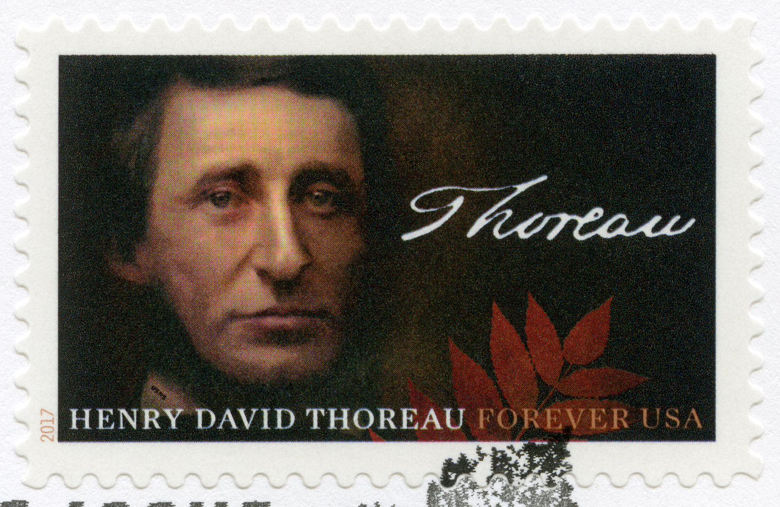
Many prominent people have gotten their start or dabbled in the art of land surveying. As we’ve covered in previous posts, well-known American figures have connected with the land through the art of land surveying. The work is ideal for those who see the beauty of the natural world. During the mid 19th century, America produced many memorable poets and writers that were essential in articulating and refining the American ethos and the philosophies of the New World. One name that is synonymous with harmonious living in the natural world — particularly as technology and cities began to grow— was Henry David Thoreau, known as an American environmental writer and essayist. When he wasn’t philosophizing and thinking profoundly about man’s relationship to nature, Thoreau was working as a land surveyor.
The Mark of Land Surveying on the Life of a Profound Thinker
Classical education in American history will likely come across the likes of Massachusetts native Henry David Thoreau and his work. With such well-composed life advice and profound thinking, Thoreau was known for his thoughts on capitalism, nature, and the individual. The son of a pencil factory owner, Thoreau became an apprentice to Ralph Walde Emerson—another big name in American literature. This meant that young Thoreau would be heavily steeped in the Transcendental tradition of his mentor. For the Transcendentalist, the way to a meaningful life was in the ability to hold oneself or maintain one’s separation from the material world and material wealth. This was an American delineation of the British Romantics, who saw the natural world as the arbiter towards spiritual transcendence and peace. Emerson wrote, “Mind is the only reality, of which all other natures are better or worse reflectors. Nature, literature, history, are only subjective phenomena.” This type of transcendentalist thinking was to inform much of Thoreau’s work, although he would depart from heavily discounting the power of nature on individual development. On the contrary, Thoreau put a lot more significance on nature and its presence in our lives.
Perhaps a little less known fact about the famous writer was that he was also a strong-minded abolitionist who participated in the Underground Railroad and railed heavily against slavery. During this time as a conductor at the Underground Railroad, he helped several slaves escape to Canada.
A Young Land Surveyor Uses Surveying to Inform His Work
As Thoreau worked parceling land that would be sold off to loggers. He used land surveying as his day job and dedicated himself to writing on his time off. He became Concord’s head surveyor in 1851. A close look at land surveying of the 19th century reveals that there were no licensing requirements to do the work. So land surveyors relied heavily on recommendations and their past work to vouch for them. Thorough was a man known in the surveying community as a man of integrity and this fared well for his ability to continue getting work.
The US Coast Survey formed in 1807 was important for the young land surveyor. The survey was conducted under the public spotlight and brought questions to the forefront about the role of science in democracy. These early surveys often had a significant impact on the shaping of society and people’s understanding of private property in the early days of the nation.
Land Surveying in the Mid 19th Century
The century has many important people working as land surveyors, but the work itself — done across the country — would help shape so much of America today. One of the most famous texts was the 18th-century treatise called “The Complete Surveyor or the Whole Art of Surveying Land.” This book was influential for other early surveyors including George Washington and Henry David Thoreau. The process of land surveying looked a little like this:
- The selling or distribution of the land to a prospective owner
- A prospective landowner would obtain a warrant
- A surveyor would go out to the location with the prospective owner
- They would mark out and demarcate the property line
- The surveyor would prepare a plat or special map of the boundaries
- The surveyor would include a textual description
- This document would serve as the deed to the land
The Long Tradition of Land Surveying in America
These figures have included the first president of the United States, George Washington, and founding father Thomas Jefferson. We have also covered the Lewis and Clarke expedition that gave way to a better understanding of the American Western frontier. The Lewis and Clarke expedition helped the American expansion efforts. In Europe at this time, land surveying would use a lot of transits, theodolites, and star charts, early surveying in the colonies used a different method that involved a long Gunter’s Chain to measure and demarcate the property. Most of the land surveyed east of the Ohio River was done using this method.
Land Surveying You Can Trust in the El Paso Area
Here at Land-Mark, we continue the great tradition of land surveying. The great predecessors of the industry have left behind great lessons of land surveying and much of their history.
As one of the Southwest’s most dependable land surveying firms, we are ready to help you survey your land with accuracy and reliability. Call us today and find out more about what we do.
The Amazing Story of Lewis & Clark: America’s Most Famous Land Surveyors (Part I)
24 November
You are given a hand compass and told to go off into this unknown territory and come back with a map and detailed drawings of the land. No GPS. No smartphone. No calls to mom. No helicopter to rescue you. It would be quite the feat! Many people today are used to the convenience and accuracy of GPS for navigation. If you drive into a new city, you likely use navigation tools to find the nearest burger place, hotel, or shopping center.
It wasn’t always like that. In fact, going into the unknown was part of this country’s early history. Somebody had to do it. That person (among others, of course) was Meriwether Lewis and William Clark when they set off West to map the unknown lands beyond the Mississippi River. This incredible history shows just how vast and expansive the United States was and is an inspiring real story of the American spirit on a tumultuous journey.
In past posts, we’ve explored the incredible technology that is changing and enhancing the work of land surveyors across the world. From drones to GPS to smart technology, mapping our world has improved through the implementation of these tools. We thought we’d go back in time to a story that had none of those technologies and surveyed over 8,000 miles with not much more than a pen, paper, and a whole lot of grit.
It Begins With the Son of a Surveyor and a Notable Name in American History
For most people, Thomas Jefferson is the name behind the Declaration of Independence and the third president of the United States of America. He is known as one of the most notable founding fathers who wrote and spoke eloquently about the role of government, led the revolutionary cause, and worked for the republic moving forward. A little unknown fact about Jefferson is that he was a son of a land surveyor and a land surveyor himself. He was exposed to the world of mapping and charting as a young boy and for a time considered pursuing this as his profession. Because of his exposure to the line of work, Jefferson understood the importance and necessity of having accurate maps and surveys of one’s country. He knew that a new nation attempting to build itself could not do without the knowledge of its own lands.
As president, Jefferson emphasized the importance of the landowner and the central role they played in building the country. All of this fueled his ambitions for discovery and exploration, as well as an understanding of what lay beyond the recent territories the country had just acquired.
The Louisiana Purchase obtained after a negotiation had added 827,000 square miles to the United States. This was a lot of unexplored territories. Jefferson was already calling for it to be surveyed. He appointed his secretary, Meriwether Lewis, a known surveyor as well, to lead the expedition. Lewis would choose his friend William Clark and together they would put together a team that would change American history and set an example for pioneers everywhere.
The Two Men That Would Spearhead the Corps of Discovery
Like many early pioneers, William Clark and Meriwether Lewis were men of their era: smart, with a drive for adventure, and a relentless spirit. Lewis went to college in his home state of Virginia and graduated in 1793, no small feat at the time. He joined the Virginia state militia and took part in putting a stop to the Whiskey Rebellion. He would go on to become captain of the U.S Army, and at the ripe age of 27, he became a personal secretary to the President of the United States, Thomas Jefferson.
William Clark joined the state militia of Kentucky when he was nineteen and would go on to serve in the regular Army. He served with his future partner Lewis and would be commanded by George Washington himself as a lieutenant of infantry.
Survey Instruments Used For the Treacherous Expedition
It might be interesting to note that Thomas Jefferson taught Lewis the basic principles of determining latitude by observing altitudes of the sun or a star with an octant. Both Lewis and Clark understood that this was not a journey to take lightly. Both prepared adequately for the journey Jefferson also sent him for formal education and once appointed to head the expedition, Lewis began studying medicine, botany, astronomy, and zoology. He would study and analyze existing maps and journals. Some of the surveying tools they had at the time included:
- Compass
- Quadrants
- Telescopes
- Sextants
- Chronometer
- Tape measure
- Thermometers
- Plotting instruments
Soon, this dynamic duo would set out for the unexplored wildlands of the West. In Part II, we’ll explore their journey, what they ran into, and what they found after miles and miles of exploration, map-making, surveying, and endless adventure.
Here at Land-Mark professional surveying, we have slightly more sophisticated equipment than Lewis and Clark, but we see every job as an adventure. For a professional land survey, contact Land-Mark today.
A Land Surveyor’s Tool Kit: What We Use in The Field
21 August
As land surveyors, we have to carry around a great deal of equipment. We’re often mistaken for photographers because of our tripods, but the rest of our gear quickly dispels that thought. We deal with precise measurements, so it’s crucial to have the right tools on hand. Here we’d like to teach more about our equipment, so you can see us and not mistake us for dedicated Instagram photographers.
- Theodolite – A theodolite is a surveying instrument with a telescope for measuring horizontal and vertical angles. Some land surveying crews use transits and total stations as well, which are used for the same purpose. These can be very pricey; they can range from $200 to over $50,000 in retail price!
- Surveying Tripod – Be sure not to spend all your money on the theodolite, because it needs a place to sit as well. The survey tripod is a sturdy tripod that is designed to move as little as possible for accurate measurements.
- Hand Tools – Besides the main equipment, a surveyor will need a host of other equipment to do the job well. Rope and measuring tape are great for rough measurements and marking, while items like picks and saws help clear debris to properly survey.
- Clipboard – All the data needs to go somewhere, right? A clipboard and pencil are necessary to take measurements or notes down onto paper, or a good PDA would suffice as well.
Land Surveying Done Right
If you’re in need of a land survey, Land-Mark Professional Surveying is the best in the southwest. We work in Texas, New Mexico, and Arizona, and provide quality land surveying for all of our clients. Contact us to see what we can do for you!
Land Surveying: The Best First Step You Can Take
15 July
 For many people, owning land is a lifelong dream. If you’ve achieved this dream, you need to look into land surveying services before you break ground and start construction. This way, you won’t face any nasty legal battles in the future. You see, avoiding surveying your land can cause adjacent landowners to seek legal ramifications against you, which can quickly turn your dream of being a landowner into a nightmare.
The Best First Step
When buying land, most people have a somewhat vague understanding of where their land’s borders are. The land seller might’ve said that the land is a few acres across, but how are you to know exactly where your land ends and your neighbor’s beings? This is where we come into play. By using state-of-the-art technology, Land-Mark Professional Land Surveying is able to provide the most accurate information so your dream can proceed without a single hitch. Our services are reliable. In fact, countless individuals and companies alike rely on us for all their land surveying needs.
It’s Time To Get Started!
So, if you’re ready to get started on the right foot, give us a call! We always strive to offer top-notch service to our clients. In fact, we also love talking about our services and processes so you can be as enlightened in the art of land surveying as us! Nothing should stand in your way when it comes to achieving your dreams. Contact Land-Mark Professional Land Surveying today.
The Path Forward: Understanding the Importance of Land Surveying
19 April Here’s a fun fact for you, did you know that three of the four presidents immortalized on Mount Rushmore were land surveyors? It’s true. George Washington, Thomas Jefferson, and Abraham Lincoln were all proud of land surveyors. It’s a beautiful thought; these men who basically build the America we know and love today also played their part in literally surveying America’s own land. The importance of land surveyors goes as far back as history immemorial. If you’re looking for land surveying assistance in the Southwest region, give Land-Mark Professional Land Surveyors a call!
What Goes Into Land Surveying
Although there have been many advancements in modern technology that have made land surveying as accurate as possible, the basic tenets of land surveying are the same as they were in Washington’s day. The measuring of properties and land in order to determine boundaries is as important in this day and age as it was back when the Louisiana Purchase first went through. Let’s say you purchased some land and you plan to develop said land. Before doing so, you must have it surveyed by a professional land surveyor. Avoiding this can lead to many issues in the future.
The Right First Step
Just imagine, you buy land, develop it, and build a shopping center over it. Then, a few years later, you find out the person who owns the plot of land adjacent to yours wants to develop it as well and a land surveyor determines you built on the neighboring land. This will undoubtedly lead to litigation and other legal issues you’d rather avoid. So, before breaking ground, hire a land surveyor. With their findings, you’ll be able to take the first steps towards building whatever you may have in mind. Even if you’re not currently planning on developing your land, it’s still a good idea to have it surveyed. This information will be incredibly useful, no matter what you plan to do with your land.
Putting Your Best Foot Forward
If you’re ready to partake in the century-long tradition of land surveying, then contact Land-Mark Land Surveying! We are the area’s foremost land surveying team which means our work is second to none. When it comes to land surveying, it’s in your best interest to not cut corners; the end result may be more harmful than good and you’ll have to face the negative ramifications further on down the road. Let our team survey your land so you can move ahead with your dreams, whatever they may be.
What Can I Do If My Neighbor Builds on My Property?
26 February
Imagine this: you’ve finally found that white-picket fence, American dream of a house that you’ve always wanted and dreamed about, and then…your neighbor starts building on your property. Whether it’s a fence that cuts into your yard or you find your neighbor pruning what doesn’t belong to him, property disputes with neighbors are actually quite common, especially when there aren’t clear barriers or lines denoting whose property is whose. Here are a few things you can do if you find yourself dealing with a property dispute.
#1: Start With a Civil Discussion
Many times, when property disputes happen, simply talking to your neighbor about it can oftentimes resolve the problem. But we know that isn’t always the case, especially when the borders dividing your yards aren’t so cut and dry. If a civil discussion doesn’t cut it, don’t fret because there are other options for you.
#2: Bring it Up With a Property Manager
If you’re renting your property, your property manager may be able to help you resolve the dispute, especially if they are renting out your neighbor’s property as well, as is the case for many neighborhoods in El Paso. However, we’ve seen that many property disputes happen between two people who own the home they live in. If that’s the case, obviously this step is one you can skip.
#3: Contact a Land Surveyor to Help
A land surveyor’s job involves surveying land to identify property lines, among other things. So, if there is a dispute between you and your neighbor, a land surveyor can help you identify where your property lines fall so you and your neighbor can build and install to your heart’s’ content without worrying about building on each other’s property.
#4: Talk to a Lawyer as a Last Resort
If all else fails, a lawyer can help you dispute the barriers as well using the information the land surveyor gathers about your property lines. It’s a worst case scenario but sometimes it has to be done.
The Importance of Land Surveying and Property Lines
Land surveying is important for all sorts of functions in life, from architecture and homebuilding to economics and landscaping. Land surveying can identify property lines, help people build and expand thoughtfully, and can help with things like habitat preservation. At Land-Mark Professional Surveying, Inc., we can help people dispute property boundary issues civilly. Call us today to learn more!