Understanding Property Lines: Land Surveys and Maps When Buying Property
28 May Whether you are a large company purchasing acres of your next commercial infrastructure, or your a government agency looking to build some kind of installation, or you’re a property investor, or even a prospective homebuyer looking to buy acreage on which to put your home, a land survey is more than likely relevant to you.
Chances are that, at some point in your life, you have seen land surveyors at work on the side of the road on your everyday commute or drive across town. It looks like they’re taking photographs, as they are looking through a telescopic-looking device sitting on a tripod. And yes, it looks like they’re out there taking panoramic photos or admiring the horizon but really they are hard at work taking specific measurements and mappings of the land. The expertise of a land surveyor is in their ability to determine land measurements, topographic heights, and more.
The Right of Way Surveys
One of the main services of many land surveyors, such as Land-Mark, include what are known as Right of Ways Surveys. This refers to the legal right, established by usage or grant, to pass through specific grounds that form part of someone else’s property. In other words, it is the right of passage to another person’s land or property. The term is a common way that land surveyors and other civil engineers use to describe the ability to access another’s property, as it pertains to land usage rights. Examples of a Right of Way might include utilities— gas, electricity, water, telephone, or drainage— to pass through neighboring land, or if your neighbor must access your land in order to get to their property.
There are a couple of options with this:
Property Right of Way: This type of Right of Way (ROW) allows individual access to a person that needs it in order to reach it another location. This might be common on properties that are adjacent to another property that has the only access to the property in question. This may be in absence of a public walkway, lake, or river.
Public Right of Way: A public ROW allows members of the public to access a right of way that is on private land.
Pipeline Right of Way: This type of ROW applies directly to utilities or services that must access private property. This is when the utility company needs to use this private piece of land in order to provide its services and are vital to its operations.
A land surveyor can help you determine the specific details of the ROW by taking measurements of the property and assessing where the property line begins and ends. It is important that if you are the property owner, that you are aware of any ROW that might pertain to your land.
Before you renovate or develop on your land…
This information is key to the development and maintenance of your piece of property. If you are planning on developing your land or building on it, knowing the specifics is essential to ensure a successful project. You don’t want to find out that you have a ROW after you have built over it or disrupted it in some way. By law, it is necessary that you are aware of these types of details on your property.
A ROW can also refer to land owned by a municipality or company that transports goods and/or people. In a way our streets and highways are located on right of ways and so access to any adjacent properties are always to be provided.
Why is a Land Survey Important for Renovations and Development of Property
Knowing precisely the dimension and topography of any site is essential in order to ensure full compliance and abidance of building guidelines, town plans, etc. Even if you think your renovation project is just a room addition or something simple, knowing the precise measurements and boundaries of your property is necessary.
If you are looking to build on your land, a planning permit and/or building permit may be required. A land survey will be a mandatory part of these planning permits.
Get Necessary Land Surveying with Land-Mark
So if you are a property owner that is looking to develop on their land, understanding the historical data that you must take into account will ensure a successful build, project, or expansion. Owning a ROW is important too, as it informs you of necessary access you must provide to others through your property. Call Land-Mark today to get quality land surveying that is not only done quickly but effectively.
How Boundary Surveys in El Paso Can Help You
22 February Trying to prove that a certain piece of land is yours, can be easier said than done. Especially if you have another party claiming that the land belongs to them. One way to settle such a dispute is to have a survey of the lands done. Land-Mark Professional Surveying has experience in performing boundary surveys El Paso. Land surveys are helpful with marking out the land. This can help settle any disputes that may be happening. In addition to this, it will provide accurate and legal documentation to prove ownership.
Settle Land Disputes with Boundary Surveys in El Paso
Using boundary surveys in El Paso can help to settle land disputes. A land dispute is when you have an issue regarding ownership. Now it may seem like it would be obvious as to who owns what land. But land can change over time. For example, certain hills and valleys that existed fifty years ago are no longer around. Or a city can build or destroy property. This too can change the way land looks and where it is marked. As a result, land owned by an individual can look like it is owned by another. This is where a survey can help. If one person claims that a piece of land is theirs. And another person also claims that land. Then the way to settle it is to check the boundary lines. This will be the most accurate and speediest way to define who owns what.
Provide Accurate Documentation
Using boundary surveys in El Paso can help prove ownership. It sometimes happens that over time, who owns what land can be difficult to see. A survey marks the land space that a person owns. This info is taken from original land deeds. Every time someone makes a land purchase, it comes with a bit of land. This info is recorded in the deed. A survey takes the measure of the land based on that survey. As the deed is also fairly specific, say 24 by 20, it cannot be altered or measured incorrectly. In other words, the survey cannot take a measure of the land as 25 by 19. It must be to the specified measures found in the deed. This way, it is practically impossible to get ownership wrong.
Figuring out who owns what land, or has a right to that land can be tricky sometimes. Land tends to change over time and it sometimes happens that boundary marks get confused. Getting a survey done on property helps prove ownership. Land-Mark Professional Surveying can perform quality boundary surveys El Paso. This is helpful in settling any disputed land and gaining papers to prove it. Getting a boundary survey done provides legal documentation to prove ownership. If you are having an issue with proving certain lands belong to you, then consider getting a survey done. This is usually the fastest and easiest way to settle the matter.
Understanding Boundary Surveys And When They Are Needed
12 October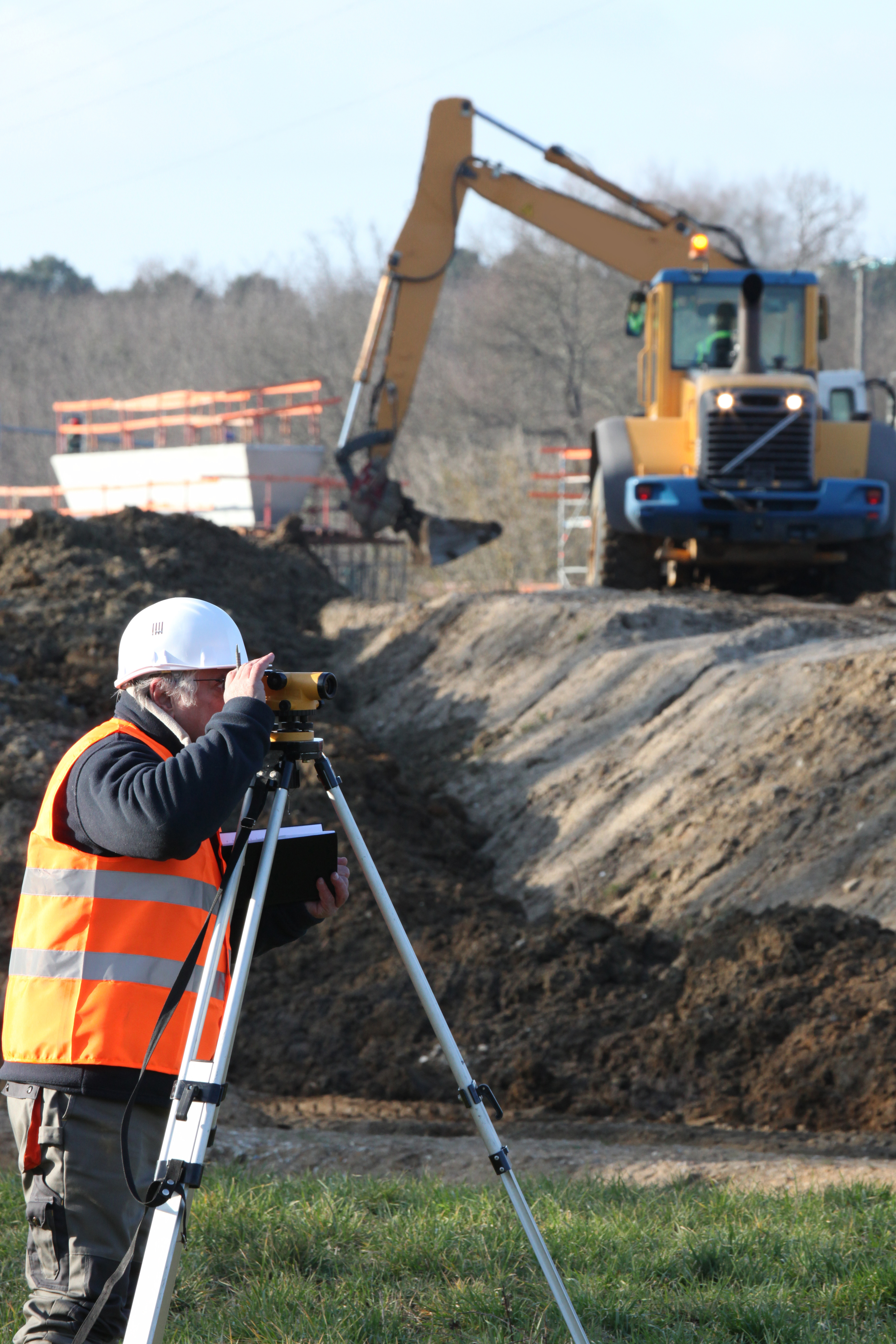
Understanding how boundary surveys work one must first understand what they are. Boundary surveys is the process conducted to determine property lines. Surveyors define true property corners of a parcel of land. Even more so, boundary surveys in Las Cruces aim to formally establish the extent of a given parcel. They comprehensively outline the extent of the property. This allows for landowners and land buyers alike to be fully conscious of the lines surrounding their land. It also permits them to have accountability of their land and that of their neighbors.
Everyone Should Be Informed Of Boundary Lines
The main reason why prospective property owners would need a boundary survey is buying a piece of land. A buyer need to know the size of the land they will buy, but also, specifically where each of the boundary lines might be drawn. This allows for both parties (the buyer and the neighbors) to maintain a civil and mutually beneficial relationship.
The second reason why they might need to conduct a boundary survey is to plan to modify or create an execution of mineral leases. It is often common that landowners decide to use their land for different activities in which they might need to construct and/or otherwise sell part of the land. In this case, a person wants to be completely confident of the set boundaries. Lastly, the state requires a boundary survey to to expand and/or build any state/government related project. In these instances, an owner really needs to know what part of land is available to offer the government.
Contact an Expert on Boundary Surveys
At Land-mark Professional Surveying, we have on-field trained personnel. Our experts are ready to answer any questions you have about your land. If you are a current landowner or if you are considering purchasing some land, don’t hesitate to let us know and we will guide you throughout the process. Call or visit us today at Land-mark Professional Surveys to make an appointment for a boundary survey in Las Cruces.
The History of the Boundary Survey
2 September Boundary surveys in El Paso identify the outer edges of a plot of land. The purpose is to make sure that the owner of the plot of land knows what pieces of ground are theirs and where their property ends. Land-Mark Professional Surveying, Inc. can provide assistance with boundary surveys in El Paso. The practice of surveying dates back even before people began building structures. Now, in the modern age, Land-Mark Professional Surveying can help.
History of Surveying
In 2,500 B.C., prehistoric surveyors set Stonehenge’s area with Peg and Rope geometry. Surveys, therefore, date back at least this far. When it comes to boundary surveys specifically, ancient Egyptians used to use simple geometry and a rope structure to conduct this type of survey. The rope structure and the geometric tools would re-establish the boundaries of lands after the Nile River flooded each year. In ancient Rome, land surveyors were professionals. With the developing of more tools, the modern surveying process began. And, in 1620, Gunter’s Chain was first introduced to make it possible for plots of land to be surveyed for both legal purposes as well as for commercial purposes. The long tradition of surveying began so long ago continues to this day.
Boundary Surveys in El Paso
And now, many years later, land surveys and boundary surveys are as important as ever. They are used for the same common reasons as they were back in ancient times. It is still as crucial as ever to have these important surveys done on your land. So, if you are buying, selling, or improving a plot of land, boundary surveys in El Paso will arm you with the information that you need to go into the transaction fully informed. We can provide you with the boundary surveying help you require. Contact Land-Mark Professional Surveying, Inc. today!
How Boundary Surveys Can Help Resolve Disputes
13 May
As the name suggests, a boundary survey in El Paso can clearly mark where your property ends and your neighbors begins. At Land-Mark Professional Surveying, Inc. we can provide such services to a property owner. This is a professional and accurate way of determining rightful boundary lines. Boundary surveys help settle disputes of other types as well, including some of these examples below.
Boundary Surveys Provide Irrefutable Proof
A boundary survey in El Paso is an excellent way to determine where you can build on your property before the work even begins. Spacious backyards are great to have but can sometimes become a source of complication when the boundaries are not so clearly set as with other types of homes. In this case, you would be better off having boundary surveys conducted before any additions are made to the property. The limits of the property you have is also important to know when you are planning to pass on your estate to a loved one after death. Professionals in the industry use metal bars to mark property lines and this is generally considered irrefutable legal proof.
Useful Documentation
It is also a useful document when you go to sell your property because it saves any potential buyer the anxiety of wondering where the property lines are. You will know exactly what is and is not included in the purchase.
At Land-Mark Professional Surveying Inc., we understand all of the latest techniques when it comes to professional boundary surveys and other types of land surveying. A boundary survey in El Paso can be easily conducted and recorded for complete accuracy for legal and personal reasons. If you are considering a land survey of any kind, then contact us today!
What Are Boundary Surveys and Why Are They Needed?
14 December
Boundary land surveys are necessary in order to determine the exact dimensions of a land that has been left to someone else. Not only will these kinds of surveys make sure that the parcel of land matches land spelled out in a will, but also find out whether or not the land has been encroached upon, and if the land is subject to any regulations at both the state and local level. There are phases of a boundary land survey that are necessary in order to make sure the rules are followed when performing one of these land surveys.
Research Must Be Done
The first step of land boundary surveys is to make sure that the land surveyor does the proper amount of research into the records involving the parcel of land. A boundary survey can be good for up to 30 years, or if/when whoever owns the land decides to break it up and sell pieces.
The Records of Boundary Construction Must Be Examined
The state of Texas has recorded data on every piece of land in the state. When the dimensions of a particular piece of land are in question, it is the job of the land surveyor to go through these records, and all documentation, to determine the boundaries. This is why it is essential that an accurate boundary survey is done, which is why you need the services of Land-Mark Professional Surveying, Inc.
Check Into All Boundary Construction Information
Land surveyors will begin at the Texas General Land Office, but this is not the only record office they must check over. They must also head on over to the county clerk, the county appraisal district, utility companies, and any other departments that may have any information about the piece of land in question. From all of this information, a land surveyor will create a sketch of the land based on the information that was uncovered.
The Field Work and Final Survey
After all records have been looked at, and a sketch has been created, it is time for some work out in the field. At this time, it is time for an actual survey, and a land surveyor may use the aid of technology such as a GPS device. Once the land has been scanned, and technology has been used to map it out, then a final survey is done, and all lines of the land are located.
When it comes time for a land boundary survey, Land Mark Professional Survey, Inc., is able to handle such survey. Contact our offices today for more information.